SuperMap 3D GIS is the 3D side of the SuperMap GIS platform from Beijing SuperMap Software. In short, it lets teams load oblique photos, BIM, point clouds and terrain into one 2D and 3D model. Then they process it in iDesktopX, publish it with iServer and view it in a browser through iClient3D for WebGL.
- SuperMap GIS is a full product family, so iDesktopX, iServer, iPortal, iEdge and iClient3D each cover one part of the job.
- Also, its 3D work centres on S3M, an open format for streaming large 3D datasets such as oblique photos, BIM and point clouds.
- BIM data can come in through IFC import, or else through SuperMap plugins for tools such as Revit.
- SuperMap suits buyers who need joined 2D and 3D, while Esri and QGIS often fit other needs better.
- Finally, licences come in editions plus paid modules, so a clear scope keeps the cost in check.
What is SuperMap 3D GIS?
SuperMap 3D GIS is the set of 3D tools built into the SuperMap GIS platform. In short, it lets you store, analyse and share 3D city and asset data in the same system as your 2D maps.
The platform comes from Beijing SuperMap Software, which was founded in 1997 and is based in Beijing. Then, in 2009, the company listed on the Shenzhen Stock Exchange. It also says it has partners in more than 30 countries and users in more than 100 countries. So it is a large vendor, even if many buyers outside China know it less well.
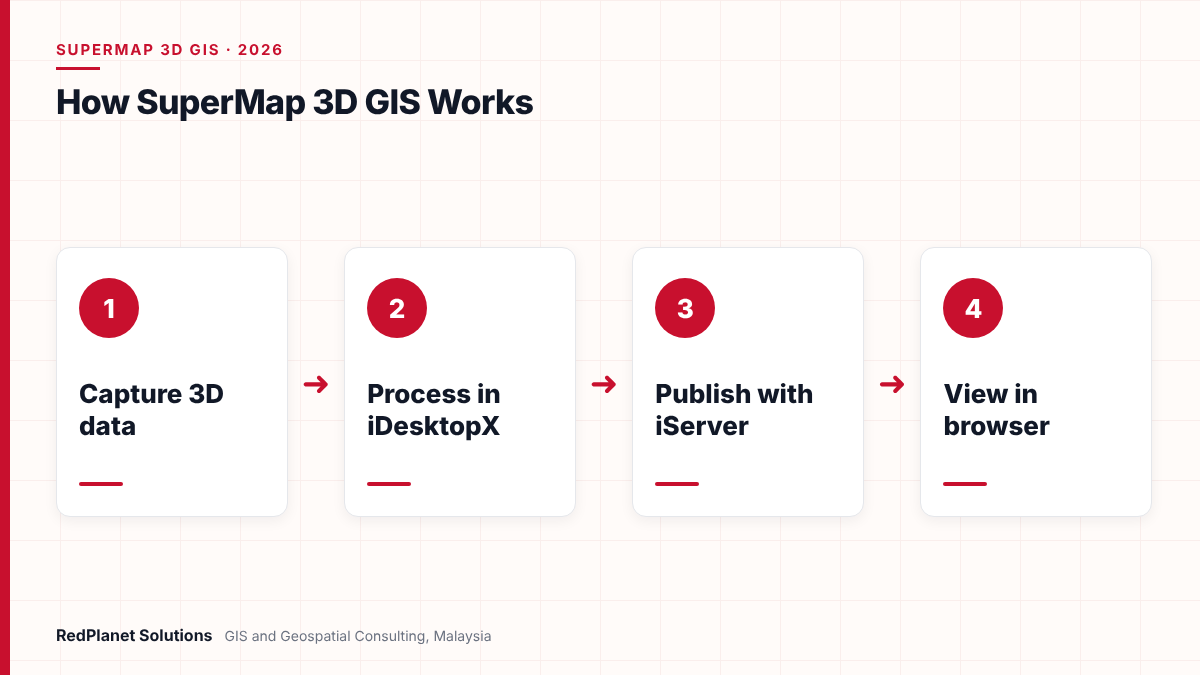
However, the key point for buyers is the design. In fact, SuperMap treats 2D and 3D as one data model, not as two products joined later. As a result, a pipe, a building and its BIM model can sit in one workspace. Our SuperMap services page also covers how we deploy and support the platform.
Which products make up the SuperMap GIS family today?
The SuperMap family splits into servers, desktop tools, web and mobile clients, and developer kits. But most 3D projects use just four of them: iDesktopX, iServer, iPortal and iClient3D.
SuperMap now names each release by year, so the current desktop is iDesktopX 2026, released in June 2026. Similarly, iServer 2026 came out in March 2026. Also, the SuperMap product system page lists the full range.
- iDesktopX: the desktop tool, so this is where you edit, process, map and analyse 2D and 3D data.
- iServer: the server, which publishes map, 3D and big data services so that web users can reach them.
- iPortal: the portal, so teams can share data and build web apps without code.
- iManager: the operations tool, which also supports Kubernetes for running services and nodes.
- iEdge: the edge server, so data can be cached and served close to users.
- iClient3D for WebGL: the web client, so 3D scenes open in a browser with no plugin.
- iObjects: the developer kits, so you can build custom apps in Java, C++ or Python.
In addition, there are mobile kits, web clients for WebGPU and Cesium, and iObjects for Spark for big data work. Notably, iDesktopX runs on both Windows and Linux. That matters if your team must run on Linux servers or local hardware.
How does SuperMap 3D GIS handle oblique photos, point clouds and terrain?
SuperMap brings most 3D data into one format called S3M, which stands for Spatial 3D Model. Then it builds caches, so large scenes can stream quickly to desktop, web and mobile users.
S3M is an open format, and its spec is public. SuperMap released the first version in 2015, then a second in 2021 and a third in 2022. Each version added better compression and new features, such as animation in the third. So the format can carry big city models without huge files.
Which 3D data types can go into one scene?
- Oblique photos: drone or aircraft photo models, and the desktop also has tools for colour balance.
- Point clouds: LAS data from LiDAR, which you can then turn into tiles or a surface model.
- BIM: building and plant models, for example from IFC files.
- Terrain: elevation grids and TIN surfaces, so the ground sits under every other layer.
- Underground pipes: pipe and cable networks, shown below the street rather than flat on a map.
- 2D and 3D vectors: parcels, roads and assets, so the map layers stay in the same scene.
For example, the 2026 desktop release adds flood simulation and geological models built from borehole data. It can also turn 3D Gaussian splat data into S3M. In addition, iServer 2026 can publish I3S caches and pass through 3D Tiles services. That helps if your data comes from other platforms. For field capture, see also our mobile mapping services.
How does SuperMap bring BIM and GIS together?
SuperMap joins BIM and GIS in two ways. First, you can import IFC files straight into iDesktopX. Second, you can export models from tools such as Revit with a SuperMap plugin, so the model lands next to your GIS layers.
The IFC import works with older IFC 2 files up to IFC4x, so most design files will open. Also, SuperMap lists plugins for Revit, Bentley DGN and CATIA. The Revit plugin then lets you set the level of detail on export. Therefore, you can keep the file light enough for a city scale scene.
- Prepare the BIM model first, and remove parts that the GIS does not need.
- Import the IFC file, or else export it with the plugin, into a SuperMap datasource.
- Place the model in the right coordinate system, so it lines up with roads, pipes and terrain.
- Build an S3M cache next, so the scene loads fast.
- Publish the scene through iServer, and then share it with web and mobile users.
BIM import is the easy part, but a model with the wrong origin or missing asset IDs is hard to fix later. So agree a BIM handover standard with your designers before the first file arrives.
This joined view is also the base of most city and plant digital twin work. For instance, a facility team can click a pump in the BIM model and see its pipe network in the GIS. Then they can trace what sits upstream or downstream.
What big data and GeoAI tools does SuperMap offer?
SuperMap also adds big data and AI tools on top of its core GIS. In particular, they cover distributed analysis, machine learning on imagery and point clouds, and AI help with drawing.
- Spark analysis: iObjects for Spark runs spatial jobs across a cluster, and iServer can also serve big data analysis as web services.
- Cloud storage: in iServer 2026, the big data tools can also read FileGDB, Shapefile and CSV files straight from S3 object storage.
- Image models: ready-made models find buildings, roads, water and solar panels, so staff start from a draft rather than a blank map.
- Point cloud AI: in 2026, SuperMap also improved point cloud segmentation for set classes, such as long power lines.
However, these tools are paid modules in most editions. So check which ones you really need before you buy. For utilities, the point cloud tools are often the most useful, because they speed up line and pole surveys. Our guide to LiDAR feature extraction for utilities also explains how that work fits into a wider asset programme.
Still, AI output is only a first draft, since a model can miss a pole or mislabel a roof. Therefore, plan a QA step where staff check the results before they enter the system of record.
How does SuperMap 3D GIS compare with Esri ArcGIS and QGIS?
SuperMap, Esri ArcGIS and QGIS can all handle 3D, but they suit different buyers. In short, SuperMap is strong on joined 2D and 3D, while Esri has the widest ecosystem and QGIS is free and open source.
Esri maintains I3S, its 3D scene layer format, as an open spec. Notably, the OGC lists I3S as a community standard. In contrast, QGIS is released under the GNU GPL, and it offers a 3D map view for terrain, meshes and point clouds. For a wider look, see also our guide on QGIS vs ArcGIS for utilities.
| Factor | SuperMap | Esri ArcGIS | QGIS |
|---|---|---|---|
| Cost | Editions, then modules. | Paid, so plan licences. | Free, but needs support. |
| 3D format | S3M, but reads I3S too. | I3S, also an OGC standard. | Reads common formats. |
| Desktop | Windows and also Linux. | ArcGIS Pro on Windows. | Windows, Linux and macOS. |
So which one fits? If you need large 3D city models, BIM and oblique photos in one scene, SuperMap is a strong option to test. But if you already run a large ArcGIS estate, then adding 3D in Esri ArcGIS is often simpler. Likewise, if your budget is tight and your team can support open source, start with QGIS. Finally, if you must share 3D data across platforms, plan for I3S, 3D Tiles and S3M from day one.
Where is SuperMap 3D GIS used in smart cities and utilities?
SuperMap 3D GIS fits work where people must see above and below ground together. So smart city planning, utility networks, flood risk and large sites are the most common examples.
- City planning: planners can test new buildings in a 3D city model, and then check height, shadow and views.
- Underground networks: teams can show water, gas and cable networks in true depth, so diggers know what lies below.
- Power lines: LiDAR point clouds help check lines, poles and nearby trees, because clearance is easier to see in 3D.
- Flood risk: the 2026 flood tool links a 2D water model with 3D scenes, so you can see which areas may flood.
- Plants and campuses: BIM and GIS together give one view of a building and its site, so facility teams work from one record.
In Malaysia, the national Smart City Framework was launched in September 2019. Since then, local smart city plans have needed good base maps and 3D city data. So a joined 2D and 3D platform can help councils and agencies plan and share that data. Our guide to smart city GIS in Malaysia also covers the local picture.
In our experience, utility teams get the most from 3D when it answers a daily question, such as where a cable runs under a new road. But a city model with no link to asset records rarely earns its cost.RedPlanet Solutions
For utilities, 3D adds most value if it sits on a sound network model. For example, a 3D scene can show clash risks before a dig. But the trace still depends on clean 2D network data. Our article on GIS for utilities also explains that base layer.
Weighing SuperMap 3D GIS for a city, utility or facility project? If so, our consultants can scope a pilot with you.
Talk To Our Consultants →How does SuperMap licensing work, and what should you buy first?
SuperMap sells each product in editions, and then adds extension modules on top. So the price depends on the edition and the modules you pick, not just the number of users.
For instance, iDesktopX comes in Basic, Standard and Advanced editions, and each higher edition also includes the one below. Then modules such as 3D Spatial Analysis, 3D Geographic Design and Network Analysis cost extra. Likewise, iServer comes in Basic, Standard, Professional and Advanced editions. But no iServer edition includes the extended services, so the 3D service is a separate module.
Buying every module
Many teams pay for modules they never use, so map each one to a real task first.
Missing the server module
A desktop 3D scene will not reach web users if iServer lacks the 3D service module.
Ignoring the OS
Some features differ between Windows and Linux, so check the feature list for your platform.
Skipping the pilot
A short pilot on your own data shows load times and gaps, so run one before a full purchase.
Finally, get a written quote that lists each edition and module by name. Then compare it with the tasks in your scope. That way, you buy what the project needs and nothing more.
Frequently Asked Questions
What is SuperMap 3D GIS?
SuperMap 3D GIS is the 3D part of the SuperMap GIS platform from Beijing SuperMap Software. In short, it lets you combine oblique photos, BIM, point clouds, terrain and 2D maps in one data model. Then you can process the data in iDesktopX, publish it with iServer and view it in a browser with iClient3D for WebGL.
What is iDesktopX?
iDesktopX is SuperMap’s desktop GIS, so it is where teams edit, process, map and analyse 2D and 3D data. It also runs on both Windows and Linux. In addition, the 2026 release added tools such as flood simulation, geological models and AI help for drawing polygons. Finally, it comes in Basic, Standard and Advanced editions.
What is the S3M format?
S3M, or Spatial 3D Model, is an open 3D data format from SuperMap. In particular, it packs large 3D datasets such as oblique photos, BIM, point clouds and pipes into caches that stream quickly. The spec is also public, and SuperMap released the first version in 2015 and the third in 2022.
Can SuperMap import BIM and IFC files?
Yes, iDesktopX can import IFC files from older IFC 2 versions up to IFC4x and store them as a model dataset. In addition, SuperMap offers plugins for Revit, Bentley DGN and CATIA, so you can export models with a set level of detail. Then, after import, you can build an S3M cache and publish the scene.
Is SuperMap better than Esri ArcGIS for 3D?
It depends on your setup. SuperMap is strong if you need one joined 2D and 3D model with BIM and oblique photos. However, Esri has a larger ecosystem, and its I3S format is an OGC community standard. So if you already run a large ArcGIS estate, adding 3D in ArcGIS is often simpler.
Does RedPlanet Solutions work with SuperMap?
Yes, RedPlanet Solutions works with SuperMap, and also with Esri, QGIS, Hexagon and GE Vernova Smallworld. In particular, we help teams scope pilots, prepare 3D and BIM data, set up iServer and build custom apps. So see our SuperMap services page for more on how we support projects.
Is SuperMap 3D GIS the right choice for your project?
SuperMap 3D GIS is a good fit if you need large 3D city models, BIM, point clouds and 2D maps in one place. It also suits teams that want Linux support and a modular licence. However, it is not the only path, since Esri or QGIS may suit your current setup better.
So start with the questions your users ask each day. Next, check your data, from oblique photos to BIM handover files. Then run a short pilot on that data with the right modules. As a result, you will know if SuperMap earns its place before you commit to a full rollout.
Expert Guides
Related GIS Guides
 GuideHexagon Geospatial Software Explained: GeoMedia, M.App Enterprise and Luciad ComparedHexagon geospatial software explained: GeoMedia, M.App Enterprise and Luciad, their new Octave names, how they fit together and which suits your use case.Read the guide →
 GuideSmart City GIS in Malaysia: Use Cases, Data Layers and a Digital Twin RoadmapSmart city GIS Malaysia guide for local councils: use cases, core data layers, MSCF and PDPA governance, and a staged roadmap to an urban digital twin.Read the guide →
Plan Your SuperMap 3D GIS Project With Experienced GIS Consultants
RedPlanet Solutions helps cities, utilities and site owners scope SuperMap pilots and prepare 3D, BIM and LiDAR data. Then we publish scenes that link to real asset records, so talk to us about your 3D goals.
Talk To Our GIS Consultants
PK Senthilkumar is CEO of RedPlanet Solutions. His work focuses on GIS consulting, network-based GIS for utilities, enterprise GIS modernisation and practical spatial decision-making for organisations operating across Malaysia, India, Australia and international markets.
About RedPlanet Solutions
RedPlanet Solutions (M) Sdn Bhd is a Malaysia-based GIS consulting and geospatial services company and part of RedPlanet Berhad. The company delivers GIS for electric utilities, spatial data collection, drone surveying, mobile mapping and GIS software development to utilities, government agencies, smart cities and private sector organisations across Southeast Asia, the Middle East, Australia and beyond. RedPlanet works across leading commercial and open-source GIS ecosystems, including GE Vernova Smallworld, Esri, Hexagon, SuperMap, QGIS, GeoServer and FME.