Augmented Reality for Asset Management

Augmented reality is transforming how utility and telecommunications teams manage underground assets — overlaying pipes, cables, and other buried infrastructure directly onto a live camera view in the field. Instead of relying on paper maps or guesswork, crews can see exactly what’s beneath them in real time, reducing strike risk and improving decision-making on site. RedPlanet Solutions partners with Augview to bring this technology to life, helping you turn existing GIS data into an intuitive, mobile-first tool for safer, faster fieldwork.
OVERVIEW

As the authorised Augview distributor for Malaysia, South East Asia, India, Australia, and New Zealand, we help organisations access AR tools that support safer excavation, clearer asset visibility, and direct GIS-linked field workflows.

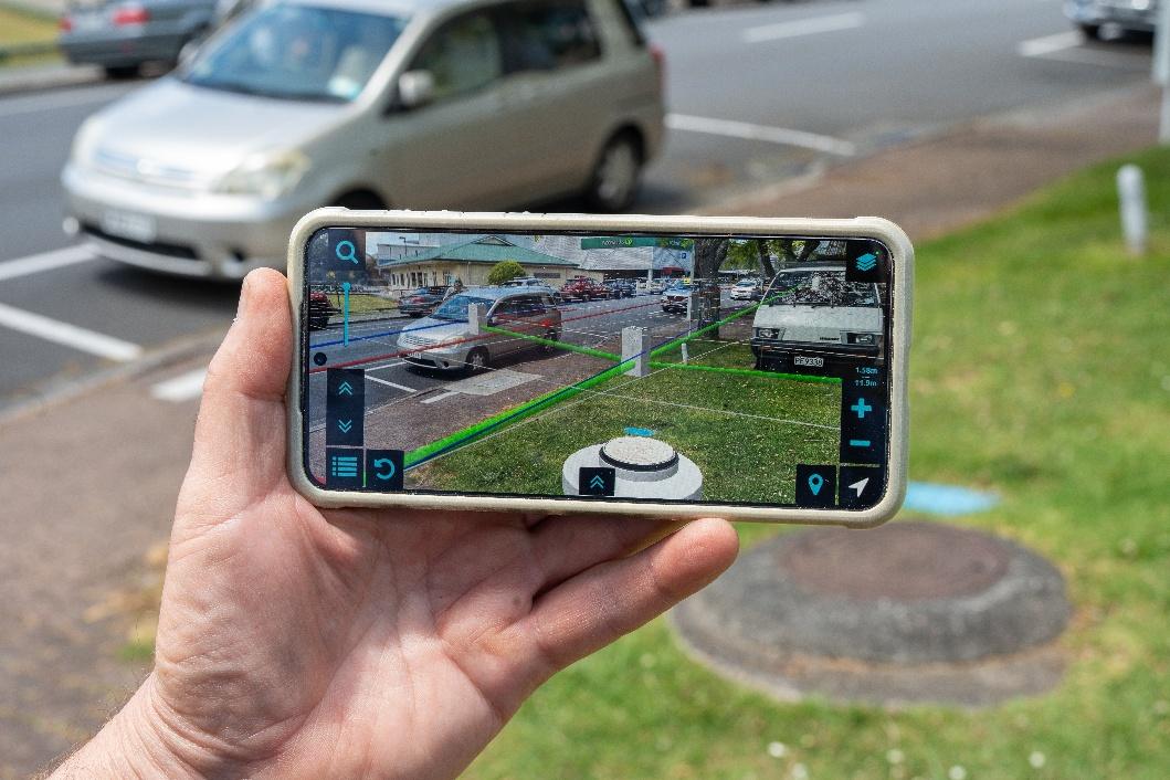
Augview gives your teams a live view of what is happening underground, overlaid directly onto the real world through a mobile device or AR glasses. This helps crews verify asset locations more quickly, reduce field errors, and make decisions with clearer site visibility.

image2

What Is Augmented Reality?

Augmented reality, or AR, overlays digital information such as asset data, measurements, and 3D models onto the real world through a phone, tablet, or AR glasses. Unlike virtual reality, AR adds digital information to the real environment instead of replacing it entirely.

In utility and infrastructure work, that means field teams can see buried pipes, cables, and other assets directly on a live camera view before any digging begins. It helps crews understand the site more quickly and work more safely.

How Augview Helps

Augview is built for day-to-day field operations, not just controlled demos or office-based planning. It pulls live asset data from your existing GIS systems and displays it in a way that is easier to understand in the field.

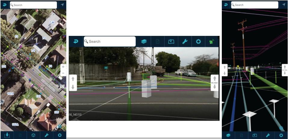
The platform supports three modes:

  • Map Mode for standard GIS viewing, navigation, and offline access.
  • Augmented Reality Mode for live overlay of underground assets on the camera feed.
  • Virtual Reality Mode for immersive 3D planning, training, and indoor environments.

A field technician can switch from standard GIS map view into AR Mode on site to confirm underground asset locations before excavation starts, then capture updates directly back into the GIS system after work is completed.

image3

Supported Hardware

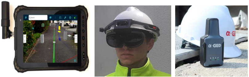
Augview works on standard Android and iOS smartphones and tablets, as well as rugged AR glasses and external GNSS units. That means many teams can start using it without investing in specialist hardware right away.

Supported devices include:

  • Smartphones and tablets with GNSS, accelerometer, gyroscope, and magnetometer sensors.
  • Rokid X-Craft AR glasses for hands-free field use, including hazardous environments.
  • External RTK GNSS units such as Leica FLX100 and AlphaGeo L2 for survey-grade accuracy.

This allows teams to test AR workflows using existing devices before expanding deployment across larger field operations.

Built For Field Work

Augview includes features that matter in real utility and infrastructure environments. For example, teams working inside substations, tunnels, or dense urban corridors can continue viewing asset overlays even when satellite positioning becomes unreliable. Multi-server access allows teams to work with data from different GIS systems in one view.

It also supports field data capture and editing, including photos, voice notes, dimensions, and direct updates to GIS records. For organisations working across multiple networks or coordinate systems, this avoids unnecessary back-office work and reduces the chance of errors.

Business Benefits

Augview helps field teams reduce avoidable excavation, improve asset visibility, and complete site work more efficiently.

Some of the main benefits include:

  • Lower operational costs through better planning and fewer reworks.
  • Better health and safety by showing underground assets before ground disturbance.
  • More accurate and timely asset records through direct field-to-GIS updates.
  • Higher productivity because crews spend less time searching, transcribing, and correcting data.

For operations and asset managers, this means fewer field discrepancies and more reliable network records over time.

Industries We Support

Augview is particularly useful in sectors where underground infrastructure and field accuracy matter most.

  • Electric utilities for planned maintenance, fault response, and network expansion.
  • Gas networks for safer excavation around buried mains and service connections.
  • Water and wastewater for asset verification, leak response, and network upgrades.
  • Telecommunications for duct, fibre, and cabinet mapping in complex environments.
  • Smart cities and local government for multi-utility coordination and field data capture.

Why RedPlanet Solutions

AR software only works when it fits real field conditions and existing GIS workflows. RedPlanet Solutions supports organisations across APAC with GIS implementation, deployment planning, and integration experience across platforms, including GE Vernova Smallworld, Esri ArcGIS, QGIS, and Hexagon.

We focus on practical deployment, so field teams can use the technology effectively in day-to-day operations, not just during demonstrations.

Frequently Asked Questions

Augview is an augmented reality and GIS asset management platform that displays planned and as-built asset data on mobile devices and AR glasses. It supports field teams with map, AR, and VR modes.

Yes. Augview integrates with GE Vernova Smallworld GNM, Esri ArcGIS, QGIS, and other OGC-compliant GIS systems. It pulls live data directly from your existing environment.

You can start with standard Android or iOS devices that your team already uses. For hands-free use or higher precision, you can add AR glasses and external RTK GNSS units.

Yes. Surface tracking and VR Mode make it useful in GPS-denied or indoor environments such as substations, pump stations, and tunnels.

It is most commonly used by electric utilities, gas networks, water operators, telecommunications providers, and smart city teams.

Get In Touch

If you manage utility, telecom, or infrastructure assets, Augview can help your teams visualise underground networks more clearly and improve field coordination.

RedPlanet Solutions can assess your GIS environment, walk you through the platform, and help you plan a rollout that fits your operations.

Speak to us today!

Explore how RedPlanet can help your organisation solve its data challenges. Speak to our team today.