
QGIS for utilities works best as a free, open source GIS for viewing, editing, checking and sharing network and asset data. Teams link it to PostGIS, GeoServer and enterprise platforms such as Smallworld or ArcGIS. It rarely replaces a full network model. Still, it cuts licence costs and gives more staff access to spatial data.
- QGIS is free, open source GIS software under the GNU GPL, so there are no per-seat licence fees.
- Most utility teams use QGIS to view, check, capture and map data, while the core network model stays in enterprise GIS.
- Firms should standardise on the Long Term Release, because every third QGIS release is an LTR with monthly bug fixes.
- QGIS links directly to PostGIS, Oracle, SQL Server, OGC web services and ArcGIS REST services, so it sits well beside enterprise GIS.
- The software is free, but support, plugins, training and data links still need a budget and a clear owner.
What does QGIS offer utility and infrastructure teams?
QGIS gives utility teams a strong desktop GIS with no licence fees. It also has a server part for sharing maps and data. So its main value is simple: more people can see spatial data without more paid seats.
In short, QGIS is a free and open source GIS released under the GNU General Public License. It started in 2002, and then joined the Open Source Geospatial Foundation (OSGeo) as a project in 2007. For the full product overview, see our QGIS consulting and support page. This guide, by contrast, looks at how utilities, asset owners and agencies put it to work.
For a utility, the real question is not whether QGIS is good GIS software. It clearly is. Instead, ask which jobs it should do. Then ask which jobs stay in the network system. Finally, ask how the two share data without a second, loose copy of the network.
How do utility teams actually use QGIS day to day?
Most utility teams use QGIS to view, check, edit lightly and print maps. It tends to sit with planners, analysts, contractors and regional offices. Core network edits, by contrast, stay in the enterprise system.
That split matters because electric, water and gas networks carry strict rules. For example, they hold links between assets, asset groups and job states. A general desktop GIS does not enforce these by default. So QGIS earns its place where people need to see and question data, but not run the network model.
Viewing network data
Engineers open read-only network layers, then add land parcels, roads and imagery on top.
Editing and digitising
Teams capture new assets and as-built drawings, often in a staging database first.
Quality checks
Analysts find gaps, copies and broken links before a move or handover, so errors stay out.
Field data
Crews check assets with QField, and then sync results back to the office.
Maps and reports
Planners print outage, design and permit maps, so sheets stay the same each time.
Spatial analysis
Analysts run buffers and overlays, for example to find assets inside a flood zone.
Field work is a common first step. For instance, a water firm may use QGIS and a mobile app for a short asset survey. It then avoids buying extra enterprise mobile licences. Our field data collection services often use this pattern for short campaigns.
Which QGIS plugins matter for network and asset work?
QGIS plugins add tools for import, checks, field sync and analysis. They help a lot, but treat each one as software you must manage, not a free extra.
Plugins are mostly written in Python and listed in the official QGIS plugin repository. However, the repository states that they come from independent developers and firms. As a result, quality and upkeep vary from one plugin to the next.
Plugin types utilities use most
- Database helpers: these load and sync data with PostGIS, so first check they write safely.
- Topology and QA tools: these find gaps, overlaps and loose ends, so check the rules and reports.
- Field sync tools: these send projects to crews and merge edits, so test conflicts and offline use.
- Network tracing tools: these answer path and service area questions, but check they follow your network rules.
- Imagery tools: these load satellite, drone or tiled basemaps, so also check the image licence terms.
Installing plugins ad hoc
Each user adds different plugins, so shared projects break. Instead, keep an approved list per QGIS version.
Ignoring upkeep
A plugin with no recent updates may fail after an upgrade. So check its activity before you rely on it.
Writing straight to live data
Point editing plugins at a staging schema first, because then errors do not reach the master network.
No owner for custom plugins
In-house plugins need a named owner and source control. Otherwise, they fall apart when a developer leaves.
If no plugin fits, a custom one is often a small Python job. Our GIS software development team also builds and maintains these for utility workflows.
Which QGIS release should an organisation standardise on?
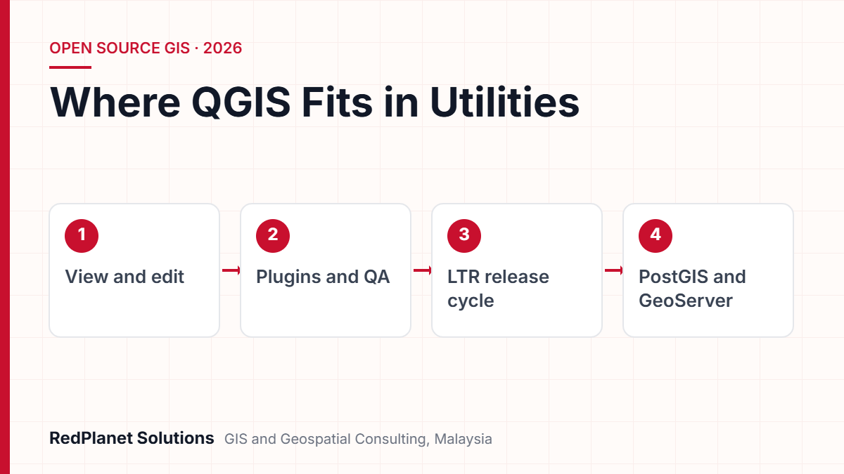
Most firms should standardise on the current QGIS Long Term Release (LTR). It changes less often and gets regular bug fixes. So IT has a stable target for testing plugins and projects.
The official QGIS release roadmap sets a new version every four months. Every third release then becomes an LTR, and it is kept until the next LTR arrives. Meanwhile, LTRs get point releases about once a month, and these hold bug fixes only. At the time of writing, 3.44 is the LTR. Next, version 4.4 is due to become the new LTR at the end of October 2026.
Pick the LTR
First, choose the current LTR as the baseline for desktops and QGIS Server.
Test projects and plugins
Next, open key projects and run approved plugins on a test build.
Roll out in waves
Then upgrade a pilot group, then regional offices, and finally contractors.
Apply point releases
After that, install the monthly bug fixes on a set schedule.
Plan the next LTR move
Finally, repeat the cycle once the next LTR has settled.
Major version changes, such as the move from 3.x to 4.x, can break plugins and scripts. So do not jump to a new major version on day one. Instead, give plugin authors time and test your own tools first.
Power users can still run the latest regular release on a spare machine. That way, they try new features while shared projects stay safe.
How does QGIS connect to PostGIS, GeoServer and enterprise GIS?
QGIS links directly to spatial databases and standard web services. So it can read, and often edit, the same data other systems use. As a result, it works beside enterprise GIS rather than against it.
The QGIS user manual lists native links to PostgreSQL with PostGIS, Oracle Spatial, Microsoft SQL Server, SAP HANA and SpatiaLite. It also reads OGC services such as WMS, WMTS, WFS, WCS and OGC API Features. In addition, it reads ArcGIS REST services. QGIS Server, for its part, can publish projects as WMS, WFS, WCS and OGC API Features.
| Source | Link type | Typical role |
|---|---|---|
| PostGIS. | Native link. | Shared store for network data. |
| GeoServer. | WMS, WMTS and WFS. | Central map and data sharing. |
| ArcGIS services. | ArcGIS REST. | Read access to Esri layers. |
| Network GIS. | Exports or services. | Read-only view of the master. |
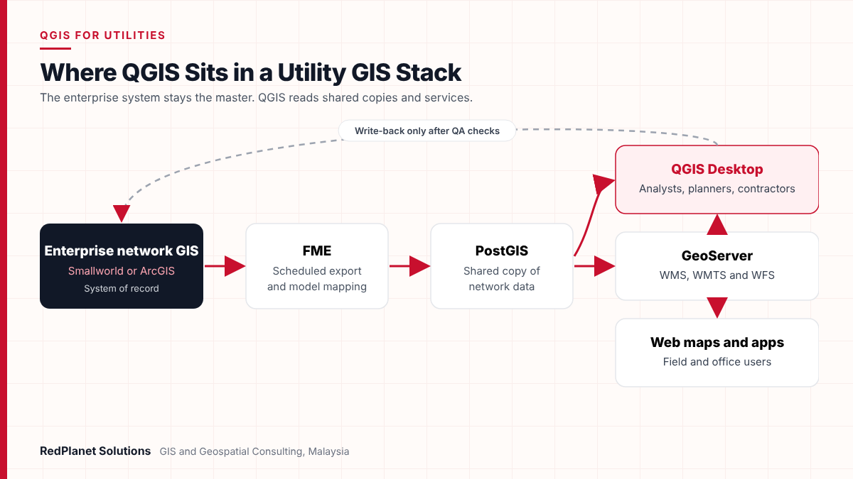
A common pattern is simple. First, the enterprise system stays the master for the network. Next, a copy lands in PostGIS on a schedule. Then GeoServer shares standard services with QGIS, web maps and other systems. Also, a tool such as FME often maps data between the models.
Write-back needs more care, though. For example, QGIS edits should pass checks before they reach the master network. Otherwise, link errors creep in, and later they show up in outage, design or asset reports.
Where does QGIS fit next to Smallworld and ArcGIS?
QGIS usually adds to enterprise utility GIS rather than replacing it. Smallworld and ArcGIS Utility Network hold the managed network model. QGIS, by contrast, brings access, analysis and field work to more users at low cost.
Platforms such as GE Vernova Smallworld and Esri ArcGIS are built for long edits, network links and design work. They also tie into SAP, ADMS and SCADA. QGIS can view and study that data, but it has no matching utility network model out of the box. So the real question is which users and tasks move to QGIS, not whether it takes over the whole programme.
If you run a large electric or gas network with design, outage and SAP links.
Then keep enterprise GIS as master, and add QGIS for viewers and contractors.
If you are a council with maps and asset lists but no complex network model.
Then QGIS with PostGIS and GeoServer can be your main GIS stack.
If many casual users need to see network data.
Then publish services and give them QGIS or web maps, not more seats.
If you need a short data capture or clean-up project.
Then use QGIS and QField on a staging database, and load results later.
In our experience, QGIS rarely replaces a utility's network GIS. Instead, it takes pressure off it, so costly seats go to the people who maintain the network while everyone else still gets good data.RedPlanet Solutions
If you are weighing the two platforms head to head, see our comparison of QGIS vs ArcGIS for utilities. It also covers licences, network models and support in more detail.
What are the limits, costs and support model of QGIS?
QGIS has no licence fees, but it is not free to run. The real costs sit in support, training, plugins, data links and staff time. Also, someone has to keep the setup the same across the firm.
No single vendor stands behind QGIS. Instead, a community runs the project, and sustaining members and donors fund part of it. So support comes from your own team, forums or paid providers. For a utility with service duties, that usually means a support deal with a partner who responds on a set timeline.
Main limits to plan for
- No packaged utility network model: so tracing and design rules need setup, plugins or custom work.
- Multi-user editing: this depends on the database design, usually PostGIS, rather than on QGIS itself.
- Mixed plugin quality: plugins come from many authors, so some lag behind new releases.
- Support model: there is no vendor help desk by default, so you must arrange service levels.
- Skills: staff trained on other GIS also need short, task-based training.
The Malaysian public sector context
Open source is not new to the Malaysian government. MAMPU launched the Public Sector Open Source Software Master Plan in 2004. It also set up an Open Source Competency Centre to guide adoption. Its stated aims included lower total cost of ownership and better data sharing between systems. So for local councils and agencies, QGIS fits a long-standing policy. Still, the same lesson applies: savings only hold when support, skills and data rules are planned from the start.
Want a clear view of what QGIS would cost and save in your firm?
Talk To Our Consultants →When should a utility bring in a QGIS partner?
Bring in a partner when QGIS must touch the master network, serve many users or meet service levels. Small, self-contained map work, by contrast, can stay in-house.
The trigger points are usually clear. For example, a data move into PostGIS carries real risk. So does a write-back route into Smallworld or ArcGIS, or a rollout to hundreds of users. In these cases, experience with both open source and enterprise platforms saves time. That is also why our GIS data migration services often sit at the centre of this work.
QGIS rollout readiness checklist
Use this list before you move QGIS from a few power users to a supported tool.
If you are comparing providers, read our guide on how to choose a GIS consulting firm. It also lists the questions to ask about open source skills and support.
Frequently Asked Questions
Is QGIS free for commercial and utility use?
Yes. QGIS is released under the GNU General Public License, so firms can install it on as many machines as they need with no licence fees. However, support, training, plugins and data links still cost time or money. So many utilities budget for a support deal with a partner, rather than relying only on community forums.
Can QGIS replace Smallworld or ArcGIS in a utility?
Usually not for the core network model. Smallworld and ArcGIS Utility Network provide network rules, design work and links to business systems. QGIS does not ship with these by default. Instead, most utilities use QGIS beside those platforms for viewing, analysis, field work and checks. As a result, they need fewer enterprise seats.
Which QGIS version should a utility install?
Install the current Long Term Release. Every third QGIS release is an LTR, and it gets monthly bug fixes until the next LTR arrives. So IT gets a stable baseline for testing plugins and projects. Also check the official QGIS roadmap for the current LTR and the next dates.
Does QGIS work with PostGIS and GeoServer?
Yes. QGIS links natively to PostgreSQL with PostGIS for viewing and editing. It also reads WMS, WMTS and WFS services from GeoServer. Many utilities use this pair as a shared data layer. For example, the network GIS feeds PostGIS on a schedule, and then GeoServer shares standard services with QGIS and web maps.
Are QGIS plugins safe to use on network data?
Plugins come from independent developers, so quality and upkeep vary. Still, they can be safe if you manage them. First, keep an approved list for each LTR. Next, test plugins on a staging database. Also avoid tools that write straight to live network data without checks, and confirm each plugin is still maintained.
Can field crews use QGIS on mobile devices?
Yes, through companion apps. For example, QField opens QGIS projects on Android and iOS devices. So crews can capture and check assets offline, and then sync results back. Because the project is set up in desktop QGIS, forms, symbols and rules also stay the same in the office and the field.
Is QGIS the right choice for your utility or infrastructure team?
QGIS is a sound choice for viewing, analysis, field work, data checks and map output. However, it is strongest beside an enterprise network GIS and a well-built PostGIS and GeoServer layer, not in place of them.
So the next step is to decide which users and tasks move first. Then pick the LTR, and agree how edits flow back to the master data. That way, licence savings turn into lasting value. If you want help with that plan, get in touch with our team for a short scoping call.
Expert Guides
Related GIS Guides
 GuideQGIS vs ArcGIS for Utilities: Which Fits Your Network Data Workflow?QGIS vs ArcGIS for utilities: compare licensing, ArcGIS Utility Network modelling, editing, data formats, integration and hybrid setups to pick your fit.Read the guide →
 GuideWhat Is GeoServer? How to Publish Spatial Data With OGC StandardsWhat is GeoServer? Learn how this open source map server publishes PostGIS, shapefile and GeoTIFF data as WMS, WFS, WCS and WMTS services.Read the guide →
 GuideMobile GIS Data Collection for Utilities: Field Workflows That Cut ReworkMobile GIS data collection for utilities: form design, GNSS accuracy, offline sync, photo standards and QA at source that cut field rework.Read the guide →
Plan QGIS around your enterprise GIS, not against it
RedPlanet Solutions helps utilities, councils and asset owners deploy QGIS beside Smallworld, ArcGIS, PostGIS and GeoServer. We also set up clear support, training and data rules, so the savings last.
Talk To Our GIS Consultants
PK Senthilkumar is CEO of RedPlanet Solutions. His work focuses on GIS consulting, network-based GIS for utilities, enterprise GIS modernisation and practical spatial decision-making for organisations operating across Malaysia, India, Australia and international markets.
About RedPlanet Solutions
RedPlanet Solutions (M) Sdn Bhd is a Malaysia-based GIS consulting and geospatial services company and part of RedPlanet Berhad. The company delivers GIS for electric utilities, spatial data collection, drone surveying, mobile mapping and GIS software development to utilities, government agencies, smart cities and private sector organisations across Southeast Asia, the Middle East, Australia and beyond. RedPlanet works across leading commercial and open-source GIS ecosystems, including GE Vernova Smallworld, Esri, Hexagon, SuperMap, QGIS, GeoServer and FME.