
To choose a GIS consulting firm, evaluate six criteria: domain expertise in your industry, technical proficiency across both Esri and open-source platforms, a verified track record with client references, a documented data quality methodology, post-delivery training and support, and commercial transparency on licensing and IP ownership. Prioritise any firm that asks about your existing data environment before recommending a platform, that question alone tells you a great deal about how they work.
- GIS consulting has shifted from map-making support to a core strategic discipline tied to AI, real-time data, and digital infrastructure.
- Technical credentials alone are not enough. Domain knowledge, data governance, and post-delivery support are where most firms fall short.
- Matching the firm type to your organisation's GIS maturity level matters as much as matching on technical skill.
- The biggest red flag in any GIS sales process: a firm that recommends a platform before asking what data you already have.
- AI integration, cloud-native architecture, and digital twin capability have become the primary differentiators in 2026.
Why This Decision Matters More Than Ever
Geographic Information Systems have quietly become one of the most consequential technologies in global business. Governments use GIS to plan cities and manage disasters. Utilities deploy it to monitor infrastructure across thousands of kilometres. Retailers use spatial analytics to site new locations and model supply chains. By 2026, with AI-powered geospatial analysis now integrated into platforms from Google, Microsoft, and Esri, the technology has moved firmly from specialist tool to strategic infrastructure.
That shift matters for anyone choosing a GIS consulting firm because the landscape of providers has changed dramatically. What was once a niche field dominated by a handful of Esri-certified specialists has become a global ecosystem of firms ranging from boutique spatial analytics studios to full-scale digital transformation consultancies with GIS practices embedded inside. The range is wide, and quality varies enormously.
Choosing badly is expensive, not just in project fees. Spatial datasets built to the wrong specifications cannot easily be repurposed. Platforms implemented without interoperability planning become migration problems. GIS infrastructure that requires the original consultant for every change is a recurring cost rather than a one-time investment. And in regulated markets, non-compliant spatial data can trigger penalties that dwarf the original project budget.
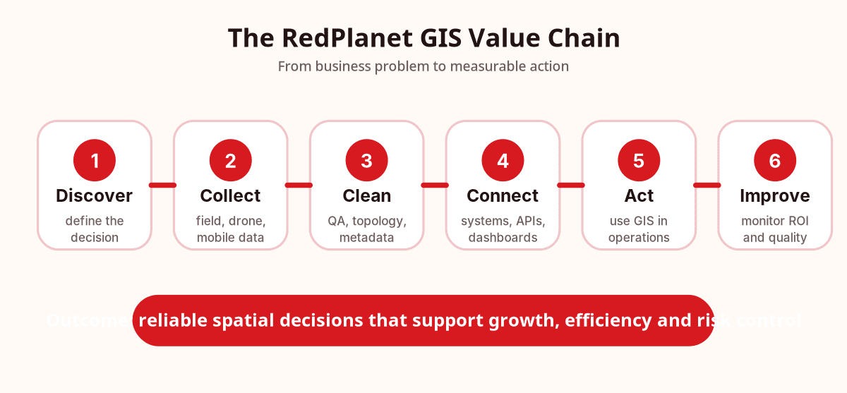
What a GIS Consulting Firm Actually Does
Geographic Information Systems (GIS) is the integrated set of hardware, software, data, and methods used to capture, manage, analyse, and visualise spatial data. A GIS consulting firm applies this capability professionally, on behalf of organisations, to solve real problems in the physical world.
It is worth being clear about what that scope actually includes, because many buyers underestimate it. A capable geospatial consulting firm can do any or all of the following: design spatial data strategy and infrastructure; implement platforms like Esri ArcGIS, QGIS, GE Vernova Smallworld, GeoServer, and Hexagon Geospatial; capture spatial data via drone surveys, mobile mapping, and LiDAR (Light Detection and Ranging); conduct spatial analysis and modelling; build custom GIS applications; manage data migration, digitisation, and quality assurance; and train internal teams to use and maintain GIS independently.
The important distinction: a general IT consultancy that employs one or two GIS specialists is not a GIS consulting firm. When projects get technically demanding or domain-specific, that difference becomes visible quickly.
The Six Criteria That Separate Good Firms from the Rest
Most buyers evaluate GIS firms on two or three dimensions. The firms that deliver reliably are evaluated across all six. A genuine weakness in any one of them is a risk; weakness in two or more is a structural problem.
Domain Expertise
Sector-specific knowledge, utilities, government, agriculture, not just software fluency.
Technical Proficiency
Platform independence, Esri, QGIS, cloud GIS, spatial Python, not vendor allegiance.
Verified Track Record
Client references you can call, not polished case studies you can only read.
Data Quality Methodology
Documented processes for accuracy, Coordinate Reference System (CRS) management, and metadata compliance.
Post-Delivery Support
Maintenance contracts, training tailored to your team, and a knowledge transfer plan.
Commercial Transparency
Clear IP ownership, licence costs, scope change processes, and no hidden platform fees.
1. Domain Expertise
The spatial analysis required for oil and gas pipeline routing is nothing like the modelling used for retail site selection or epidemic tracking. GIS tools can be common across industries; the judgment to apply them correctly is not. Before assessing any firm's technical stack, assess its industry knowledge.
Ask for case studies from your sector, electric utilities, water infrastructure, agriculture, smart cities, telecommunications. Then ask whether those case studies describe a spatial problem being solved, or a GIS platform being deployed. The difference tells you which firms think and which firms simply execute.
2. Technical Proficiency Across Platforms
A capable geospatial consulting firm in 2026 should work fluently across Esri ArcGIS (the enterprise standard in North America, Australia, and the Middle East), QGIS and the open-source stack including PostGIS, a spatial extension for the PostgreSQL database, GeoServer, and GDAL (Geospatial Data Abstraction Library), cloud GIS services on AWS, Microsoft Azure, and Google Cloud, and spatial Python and R for analytical workflows. A firm that defaults to a single platform regardless of project requirements is optimising for its own workflow, not your outcome.
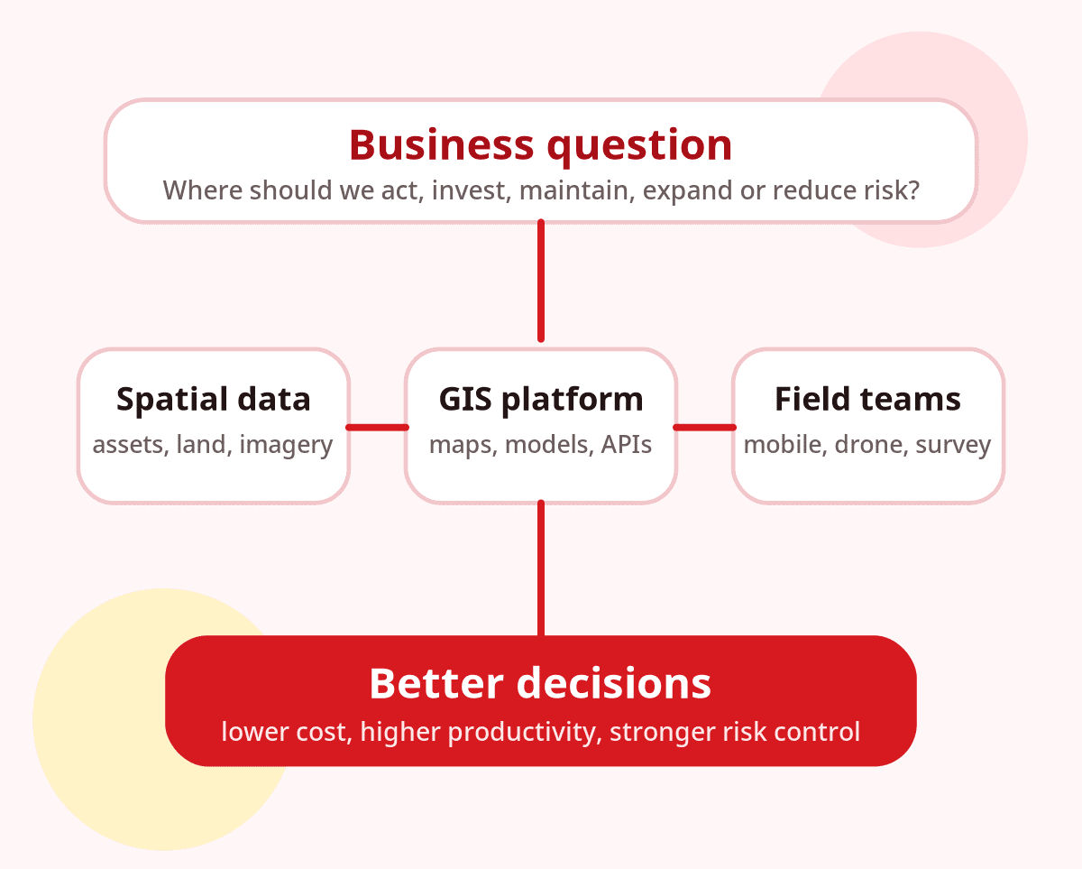
If a firm's first question is about which GIS platform you prefer, not what spatial data you already have, take that as a warning sign. Good firms start with your data environment. Platform recommendations follow from there.
3. Verified Track Record
Case studies are the minimum. What matters more is what happened after delivery. Did the system still function correctly six months later? Did the client's team adopt it confidently? Were the compliance requirements met? Ask for three to five references you can call directly, and ask each one: "What went wrong, and how did the firm respond?" That question reveals more about a firm's character than any portfolio.
4. Data Quality and Governance Methodology
This is the criterion most buyers underweight, and the most common cause of post-delivery failures. Spatial data quality is not self-evident. Mismatched Coordinate Reference Systems (CRS), attribute inconsistency, topology errors, and missing metadata are problems that often surface months after a project closes, when the cost to fix them is far higher than it would have been to prevent them. Ask to see the firm's data quality methodology as a written document. If one does not exist, that alone is disqualifying for any project with accuracy requirements.
5. Post-Delivery Support and Training
A GIS system delivered without internal capacity to maintain it is a liability. A good consulting firm actively builds your team's independence, it does not maximise your dependency on external support. Confirm that training is included in scope, tailored to your team's existing skill level, and designed around the specific system being delivered. Then ask what happens if a key staff member leaves the consulting firm mid-project. The answer tells you how robust their delivery model actually is.
6. Commercial Transparency
Before any GIS consulting contract is signed, have legal counsel review the intellectual property clause. It is surprisingly common for firms to retain ownership of analytical models, processed datasets, or custom spatial algorithms developed during a project. Recovering improperly assigned IP after delivery is expensive and sometimes legally impossible. Beyond IP, clarify: who holds software licences at project conclusion, how scope changes are priced, and whether the fee structure is fixed-price or time-and-materials.
Unsure which GIS capabilities your project actually needs? Our team can give you a no-obligation assessment before you issue a single RFP.
Talk To Our ConsultantsMatching the Right Firm to Your Situation
The most common procurement error in GIS consulting is selecting a firm based on credential rankings rather than fit. A Level 1 organisation, with no existing GIS infrastructure, needs an entirely different type of engagement to a Level 4 organisation with a cloud-native spatial platform and a strong internal team. Mismatch in either direction wastes budget and delays results.
Most organisations in Southeast Asia and the Gulf region are at Level 1-2. Most government agencies in Australia, New Zealand, the UK, and North America sit at Level 2-3.
Which Type of GIS Firm Do You Actually Need?
The GIS consulting market includes several structurally different firm types. Choosing the wrong type, even if the firm is technically strong, creates problems that neither party can easily recover from. Use this guide to match your project requirements to the right firm type before shortlisting begins.
No existing GIS and you need to build from scratch
Full-service GIS consultancy with a strong training and knowledge transfer component
Domain-specific project, utilities, mining, agriculture, or defence
Sector specialist or full-service firm with verifiable experience in your industry
Operational GIS and need AI integration or digital twin capability
Boutique spatial analytics firm or AI-enabled GIS consultancy with deployed project evidence
GIS must connect to SAP, Salesforce, or Microsoft Dynamics
Full-service digital consultancy with a dedicated GIS practice operating independently of general IT
Budget-sensitive project with a well-defined, bounded scope
Open-source GIS specialist deploying QGIS, PostGIS, and GeoServer, apply the same six-criteria evaluation regardless
When RedPlanet Solutions Is a Strong Fit
RedPlanet Solutions is a strong fit when your organisation needs more than a map. The best use cases are projects where spatial data, field operations, enterprise systems and business decisions need to work together.
Enterprise GIS and system integration
For organisations that need GIS connected to asset management, reporting, field operations, dashboards or internal business systems.
Utility, telco and infrastructure GIS
For asset-heavy teams managing networks, inspections, service territories, outages, maintenance and regulatory reporting.
Drone surveying, mobile mapping and field data
For projects that require reliable spatial data collection before analysis, migration or platform implementation can succeed.
Smart city, agriculture and location intelligence
For teams that need spatial data to support planning, monitoring, operations and long-term decision-making.
If you only need a quick one-off map styling task, a freelance GIS technician may be enough. If your challenge involves data quality, integration, field workflows or long-term decision support, a consulting partner is usually the safer choice.
Three Rules That Will Protect Your GIS Investment
After two decades of GIS consulting practice across five continents, RedPlanet Solutions' team has distilled three principles that reliably separate well-chosen GIS partnerships from costly ones.
"Technical excellence in the wrong tier is a structural mismatch, not a quality problem."
A highly capable AI-GIS boutique is the wrong choice for an organisation with no spatial data infrastructure. A commoditising generalist is the wrong choice for a complex infrastructure digital twin. Fit precedes quality in every GIS engagement. Identify your organisation's maturity level before evaluating any firm.
"If a GIS firm's first question is about platform preference, not your data environment, move on."
Platform-first thinking reveals a delivery model optimised around the firm's own toolset, not your spatial problem. A genuinely capable firm begins by understanding what data you already have, what systems it must integrate with, and what your team can maintain. Platform recommendations follow from those answers.
"Ask any GIS firm to describe a project where they recommended against their preferred platform."
A firm that cannot describe this situation is vendor-aligned, not client-aligned. The ability, and willingness, to recommend Esri, QGIS, GeoServer, Hexagon, or a cloud-native stack based solely on project fit is the most reliable indicator of genuine geospatial expertise.
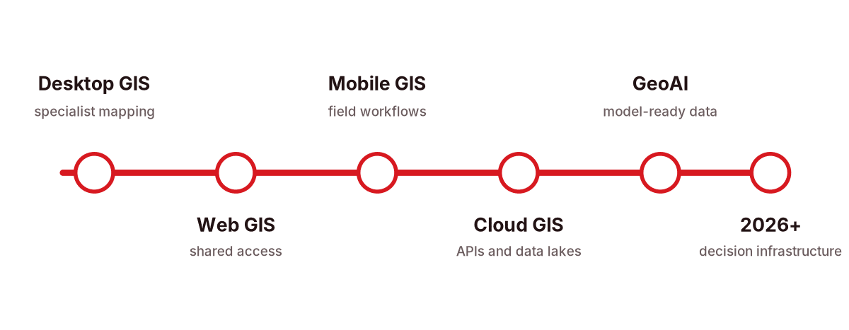
What Changed Between 2020 and 2026
Buyers applying 2020-era evaluation criteria in 2026 are making structurally outdated decisions. Five developments have reshaped the market, and they have direct implications for which firms are genuinely capable today.
On-Premises, Desktop-First Standard
Most GIS engagements centred on on-premises Esri deployments and batch-data workflows. Cloud GIS and open-source alternatives were secondary considerations for most enterprise buyers.
Cloud Adoption Reaches Commercial Maturity
ArcGIS Online, Google Earth Engine, and AWS spatial services became enterprise-ready. GeoServer and PostGIS on containerised cloud infrastructure proliferated. Open-source GIS began seriously challenging proprietary platforms on cost.
AI and Real-Time Data Become Deliverable
Machine learning-based object detection in satellite imagery reached commercial deployability. Internet of Things (IoT) sensor networks pushed demand for near-real-time GIS. Digital twin pilots expanded from research into production in Singapore, the UAE, and the UK.
Regulatory Complexity Becomes a Project Constraint
The EU AI Act, Australia's Privacy Act reform, and India's Digital Personal Data Protection Act introduced hard compliance requirements for spatial data projects. Satellite imagery costs fell materially as Planet Labs, Satellogic, and Umbra Space expanded global coverage. (Source: commercial satellite industry market reports, 2025.)
AI-Native GIS Is Now the Baseline Expectation
Large Language Model (LLM)-powered spatial interfaces, automated feature extraction, and AI-assisted mapping tools are commercially expected in 2026. Firms without AI-literate GIS practice are structurally behind. Digital twin integration has become the tier-one differentiator for infrastructure and smart city GIS projects.
Regional Buyer's Guide: GIS Consulting by Market
GIS consulting market maturity, regulatory requirements, available talent, and typical project budgets vary significantly by region. The firm selection criteria that apply in North America do not translate directly to Southeast Asia or the Gulf. Here is what buyers in each major market need to know.
GIS Consulting in Malaysia, Singapore, and Southeast Asia
This is a high-growth market. Singapore's Smart Nation initiative has made it one of the world's most sophisticated urban GIS environments. Malaysia's National Spatial Data Infrastructure, MyGDI, is maturing, though implementation quality varies considerably across sectors. Any firm engaging in this market should have genuine local data knowledge, including familiarity with national Coordinate Reference Systems such as GDM2000, Malaysia's Geocentric Datum of Malaysia 2000, and SVY21, Singapore's national coordinate system. RedPlanet Solutions is headquartered in Malaysia and serves this region extensively.
GIS Consulting in Australia and New Zealand
Both markets are sophisticated GIS buyers, with strong demand across government, mining, agriculture, and utilities. Geoscape Australia provides high-quality foundational spatial datasets, and Land Information New Zealand (LINZ) maintains authoritative cadastral and topographic data. Look for firms familiar with the Australian Intergovernmental Committee on Surveying and Mapping (ICSM) standards and with demonstrated experience navigating state and federal government procurement processes. RedPlanet maintains a subsidiary in Australia serving both markets.
GIS Consulting in the UAE, Saudi Arabia, and the Middle East
Among the world's most ambitious GIS buyers in 2026, driven by smart city programmes, urban expansion, and Vision 2030-aligned national strategies. NEOM and comparable megaprojects are creating demand for 3D GIS, digital twin capability using CityGML open standards, and real-time spatial monitoring at a scale found almost nowhere else. Firms competing here require demonstrated large-scale infrastructure project experience, Arabic-language GIS capability where relevant, and a clear understanding of data sovereignty rules within GCC jurisdictions.
GIS Consulting in the UK, Germany, and Europe
The UK's Ordnance Survey remains a global benchmark for spatial data quality. Across the EU, the INSPIRE Directive, Infrastructure for Spatial Information in Europe, mandates interoperable spatial data infrastructure across all member states. Any firm working in this market must demonstrate explicit INSPIRE and ISO 19115 metadata compliance, and should understand the EU AI Act's implications for AI-assisted geospatial products.
GIS Consulting in India
India's GIS market has grown rapidly, driven by the Svamitva Scheme for drone-based rural property mapping, the Smart Cities Mission, and the National Geospatial Policy 2021. The market is large and price-competitive, but quality variation between firms is significant. Prioritise firms with verifiable experience working within India's National Map Policy guidelines and with data frameworks from ISRO (Indian Space Research Organisation). RedPlanet Solutions operates an India office serving this market.
GIS Consulting in the USA and Canada
North America represents the most mature GIS consulting market globally. Esri Inc., headquartered in Redlands, California, dominates enterprise GIS here, with major procurement driven by agencies including the US Geological Survey (USGS) and Department of Defense. For buyers in this market, the challenge is not finding GIS firms, it is distinguishing genuinely capable ones from generalists holding Esri certification as their primary credential.
Technology Trends Every Buyer Should Understand
Geospatial Artificial Intelligence
AI-augmented GIS is no longer experimental, it is commercially deliverable. Object detection in satellite imagery, predictive spatial risk modelling, automated feature extraction from LiDAR (Light Detection and Ranging) data, and AI-assisted route optimisation are now available from capable firms. Esri's ArcGIS Pro 3.x series has introduced AI-assisted mapping tools, and multiple firms now offer Large Language Model (LLM)-powered spatial query interfaces for non-technical users. (Source: Esri Inc., ArcGIS Pro release notes, 2025.)
When evaluating a firm's AI capability, ask for evidence of specific deployed projects, not certifications or general AI experience claims. Also verify that the firm understands the limitations: training data bias for non-Western geographic contexts, edge case failures in novel terrain, and explainability requirements for regulated applications.
Cloud-Native Spatial Infrastructure
On-premises GIS deployments are giving way to cloud-native architectures on AWS, Microsoft Azure, and Google Cloud, using services including PostGIS, Amazon Location Service, Google BigQuery Geospatial, and ArcGIS Enterprise on cloud. The benefits are real: scalability, reduced hardware overhead, and simpler integration with other enterprise systems. But cloud GIS also introduces risks, data egress costs, vendor dependency, and data residency compliance requirements under GDPR (General Data Protection Regulation), Australia's Privacy Act, and India's DPDPA, that a capable firm should address explicitly in any architecture proposal, not leave to the client to manage.
Digital Twins and 3D GIS
Digital twins, dynamic, real-time three-dimensional representations of physical environments, grounded in GIS coordinate systems and updated from IoT sensor feeds, have moved from pilot to production in Singapore, the UAE, South Korea, and the UK. Dominant tools include Esri CityEngine and ArcGIS Urban, combined with open standards including CityGML (a 3D city model standard from the Open Geospatial Consortium) and IFC (Industry Foundation Classes, the Building Information Modelling standard from buildingSMART International). Digital twin capability is a distinct engineering discipline, do not assume it is included in general GIS competence. If your project requires it, evaluate it separately and explicitly.
The Real Cost of Getting This Wrong
The cost of a failed GIS engagement extends well beyond the project fee. Understanding the full exposure puts the investment in proper due diligence into perspective.
| What Goes Wrong | The Downstream Cost | Risk Level |
|---|---|---|
| Rework from wrong specifications | Re-processing spatial data can cost two to five times the original data capture budget. It is rarely avoidable once the data has been collected incorrectly. | High |
| Platform migration | Moving from proprietary formats stored without export-ready structure involves significant data conversion, validation, and QA effort, often spanning months. | High |
| Delayed decisions | Infrastructure investment, environmental permits, logistics optimisation, all deferred while GIS systems are fixed or replaced. Opportunity cost is rarely counted but is always real. | High |
| Regulatory non-compliance | In the EU (INSPIRE), Australia (ICSM), and India (National Map Policy), data produced to non-standard specifications can trigger procurement penalties or outright project rejection. | High |
| Consultant dependency lock-in | Systems that require the original firm for any modification create hidden ongoing costs and single-vendor delivery risk for mission-critical infrastructure. | Medium |
| IP ownership disputes | Unclear contract terms can leave processed datasets or custom analytical models in the firm's legal ownership. Recovery is expensive and not always possible. | Medium |
RedPlanet Solutions offers a free initial consultation to help you scope your GIS requirements correctly before you approach any firm, including us.
Book a Free ConsultationHow the GIS Consulting Market Really Works
The GIS consulting market has significant information asymmetry, buyers typically cannot verify expertise claims before committing to an engagement. This creates predictable firm behaviours that, once understood, make it much easier to distinguish genuinely capable partners from well-positioned ones.
Commoditising Firms
Compete on price and speed. Efficient for simple, well-scoped projects. Poor fit for complex or novel engagements where generic deliverables create compounding problems downstream.
Credential-Maximising Firms
Accumulate Esri partnerships, ISO certifications, and vendor badges as substitutes for demonstrated project outcomes. Ask for post-delivery results, not portfolio breadth, to distinguish them.
Specialist Niche Firms
Deep expertise in a narrow domain, subsea pipeline GIS, ecological modelling, transit network analysis. Excellent for technically demanding, domain-specific work. Wrong choice for broad infrastructure assignments.
Full-Service Digital Consultancies
GIS as part of a broader digital transformation portfolio. Valuable where GIS must integrate with SAP, Salesforce, or Microsoft Dynamics. Often underinvest in spatial depth relative to general IT capability.
Define your project type before selecting a firm type. A structurally mismatched firm type is not fixable by technical skill or strong relationship management. This is why applying the Maturity-Fit Rule before any other criterion is so important.
"Interoperability is the single most important principle in sustainable GIS investment. Proprietary lock-in, across platforms, data formats, or licensing structures, is the structural risk that derails more geospatial programmes than any technical failure.", Open Geospatial Consortium (OGC), published institutional position on spatial data infrastructure. ogc.org/standards
The Five Most Costly Mistakes Buyers Make
Over-indexing on Esri certification
Esri Authorised Reseller status signals a commercial relationship with Esri Inc., not the quality of a firm's geospatial thinking. Some of the most capable spatial analysts globally are QGIS-native professionals who hold no Esri credentials at all.
Framing GIS as a map-making service
If your procurement team defines GIS as "getting some maps done," you will under-specify the engagement and pay for capability that was never properly activated. GIS is a spatial decision-support infrastructure. Framing it correctly at the outset shapes every downstream decision.
Skipping the IP clause review
It is common for GIS consulting contracts to include language under which the firm retains intellectual property in analytical models or processed datasets. Always have legal counsel review this clause before anything is signed.
Evaluating on delivery, not on maintenance
GIS projects tend to look their best at handover. The more predictive question is what the system costs and requires to maintain six months later. A beautifully built platform that requires the original firm for any change is a recurring cost dressed as a one-time investment.
Specifying data standards after procurement
For government and infrastructure clients, data produced to non-standard specifications may fail compliance audits post-delivery. The relevant standards, ISO 19115, OGC standards, INSPIRE (EU), ICSM (Australia), or India's National Map Policy, must be specified in the project brief, not added as requirements after the work is done.
What's Coming Next
The following represent analytical observations on market direction as of May 2026, not guaranteed outcomes.
AI-native GIS becomes the minimum bar by 2027
Firms that cannot demonstrate AI-augmented spatial workflows, automated feature extraction, LLM-powered query interfaces, predictive geospatial modelling, will find themselves excluded from a growing share of enterprise projects as buyer expectations shift from "can you do this?" to "why can't you?"
Open-source GIS market share continues growing
As budget pressures intensify globally and the QGIS 3.x ecosystem matures, more organisations will select open-source stacks for non-critical and cost-sensitive applications. Firms with strong open-source capability will capture growing market share across Southeast Asia, India, and Europe.
Digital twin capability commands a premium through 2028
Smart city and infrastructure digital twin projects are multiplying across Southeast Asia, the Middle East, and Europe. Firms with credible, deployed digital twin integration experience will command premium day rates and be the first call for major government infrastructure programmes.
Data sovereignty fragments the global GIS market
Stricter national data residency rules across the EU, Australia, India, Malaysia, and GCC member states will disadvantage global GIS firms that cannot demonstrate in-country data processing capability. Regional office presence will become a competitive differentiator, not just a commercial preference.
The talent shortage worsens through 2028
Supply of GIS professionals with combined AI, cloud, and domain expertise is not keeping pace with demand in any major market. Buyers should plan for longer firm lead times and higher rates for senior geospatial specialists, and begin capability-building within their own teams now.
Comparing GIS Consulting Firm Types
| Firm Type | Best For | Strengths | Watch For |
|---|---|---|---|
| Esri-specialised partner | Enterprise ArcGIS deployment; North American and Australian government projects | Deep platform knowledge; Esri technical support access | May lack open-source and platform-agnostic capability |
| Open-source GIS specialist | Budget-sensitive or interoperability-focused projects; EU public sector | QGIS, PostGIS, GeoServer depth; lower licensing cost | May lack enterprise-grade support SLAs |
| Full-service digital consultancy | GIS integrated into broader digital transformation; ERP integration | Enterprise system integration; change management | GIS may be secondary to broader IT practice |
| Boutique spatial analytics firm | Geospatial AI; predictive modelling; research-adjacent work | Analytical depth; innovation; AI-GIS expertise | Smaller team; limited delivery scale |
| Remote sensing firm | Satellite imagery analysis; aerial survey; land cover mapping | Imagery processing; sensor data workflows | Often narrower than full GIS consulting stack |
| Regional GIS firm | Local government; national spatial data framework compliance | Local data knowledge; regulatory familiarity | May lack AI or digital twin capability |
GIS Firm Selection Checklist
18 checks across three phases. Complete all before signing any GIS consulting contract.
Frequently Asked Questions
What does a GIS consulting firm do?
What should I look for when hiring a GIS consultant?
How much does GIS consulting cost?
What is the difference between Esri ArcGIS and open-source GIS like QGIS?
How long does a GIS project take?
Is GIS consulting worth the cost?
Should I choose a local or international GIS firm?
How do I know if a GIS company is genuinely good?
The Right GIS Partner Asks Better Questions Than It Answers
Choosing a GIS consulting firm in 2026 demands more strategic thought than at any previous point in the industry's history. The technology is more powerful, the data environment is more complex, the regulatory landscape is tighter, and the cost of getting it wrong is higher.
But the fundamentals have not changed. A good GIS consulting firm understands your problem before it recommends a solution. It is honest about what it cannot do. It documents its methodology, respects your data, and builds your team's capability rather than maximising your dependency on external support.
Use the maturity model to understand where you sit before approaching any firm. Apply the three rules as your primary screening filter. Use the six evaluation criteria and the 18-point checklist as your structured due diligence process. And always speak directly with past clients before making a final decision.
The best GIS partnerships are built on clarity of scope, transparency on methodology, and mutual respect for the complexity of spatial data. Find a firm that earns that partnership from the very first conversation.
Ready to Talk?
RedPlanet Solutions is a specialist GIS consulting firm with operations in Malaysia, India, and Australia, and two decades of project experience across utilities, government, smart cities, agriculture, and infrastructure, spanning five continents.
Talk To Our GIS Consultants
PK Senthilkumar is CEO of RedPlanet Solutions and the author of this guide. His work focuses on GIS consulting, geospatial strategy, enterprise GIS, data quality, and practical spatial decision-making for organisations operating across Malaysia, India, Australia, and international markets.
About RedPlanet Solutions
RedPlanet Solutions (M) Sdn Bhd is a Malaysia-based GIS consulting and geospatial services company. The company delivers GIS consulting, spatial data collection, drone surveying, and GIS software development to utilities, government agencies, smart cities, and private sector organisations across Southeast Asia, the Middle East, Australia, and beyond. RedPlanet works across leading commercial and open-source GIS ecosystems, including Esri, GE Vernova Smallworld, Hexagon Geospatial, SuperMap, QGIS, GeoServer, and related enterprise geospatial technologies.