
Smart city GIS in Malaysia is a shared map of a council’s assets, land and services. It lets teams manage approvals, floods, traffic, utilities and waste from one trusted source. It supports the Malaysia Smart City Framework, needs PDPA-aware rules and should grow in stages, from clean base layers to live data and, finally, a city digital twin.
- Smart city GIS gives every council team one shared map, so assets, land and services sit in one place.
- The Malaysia Smart City Framework has seven parts and a 2019 to 2025 roadmap, and most parts rely on good spatial data.
- First build a small set of core layers, such as land, buildings, roads, drains and utilities, then add live sensor feeds.
- A city digital twin is the last stage of the roadmap, not the first purchase, because it only works on accurate base data.
- Rules matter as much as software, because location data about residents can fall under the amended Personal Data Protection Act.
What Is Smart City GIS and Why Does It Matter for Malaysian Councils?
Smart city GIS is a map-based system that ties a city’s assets, land records and services to their exact place. As a result, every team works from the same map instead of its own spreadsheet.
Most Malaysian local councils (Pihak Berkuasa Tempatan, or PBT) already collect a lot of spatial data. For example, planners hold zoning and approval records. Engineers keep road and drain lists. Licensing teams hold shop addresses. However, these records often sit in separate systems. So nobody sees the full picture at once.
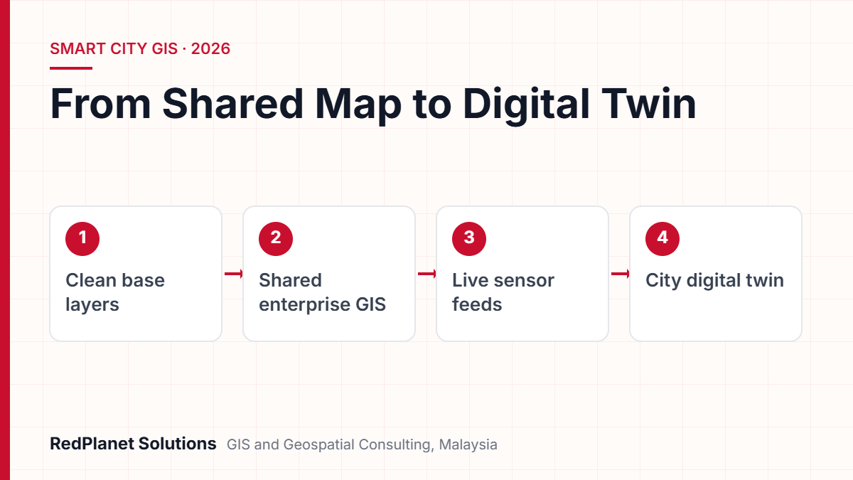
A smart city GIS fixes this with one shared location for every record. Then an officer can ask plain questions. For instance, did any drains near this new project flood last year? Also, are the streetlights on this route due for checks? In addition, do any bins sit outside the collection zone? Because the answers come from one source, decisions get faster. They are also easier to defend.
This idea sits at the heart of our smart city GIS services. In our view, the map is not the end product. Instead, it is the common language that helps planning, works and enforcement teams act together.
Which Malaysian Policies Shape Smart City GIS Projects?
The main guide is the Malaysia Smart City Framework (MSCF). The Ministry of Housing and Local Government (KPKT) launched it in 2019. So each GIS project should map to its parts.
The MSCF executive summary lists seven parts. They are Smart Economy, Smart Living, Smart Environment, Smart People, Smart Government, Smart Mobility and Smart Digital Infrastructure. The roadmap runs from 2019 to 2025 in three phases. It also calls for open data, data sharing and a smart city dashboard. But all of these need a sound spatial layer underneath.
Smart city rating and planning guides
In 2023, KPKT announced the Malaysian Smart City Rating through PLANMalaysia. It draws on ISO 37122:2019, the global standard for smart city indicators. Also, it has four stages, from Early Adopter to Visionary Smart City. Councils that earn a status get priority for smart city funds. In addition, PLANMalaysia issued a 2024 guide on smart city features in new projects. Notably, it names GIS and digital mapping as key tools.
MyDIGITAL and national geospatial data
Next, the MyDIGITAL blueprint came out in February 2021. It sets the national path for the digital economy and digital government. For map data, the Malaysian Geospatial Data Infrastructure (MyGDI) has long been the national hub for sharing public geospatial data. So a council GIS should swap data with these national sources. That way, it does not rebuild layers that already exist.
What Are the Most Useful Smart City GIS Use Cases for Local Councils?
The best use cases are the jobs a council does every day. They include assets, approvals, floods, traffic, utility works and waste. Because each one saves time fast, it also builds support for the wider plan.
Asset management
Map roads, drains, lights, signs, parks and buildings with their condition. Then plan repairs by area and risk, not by complaint.
Planning approvals
Check a new plan against zoning, past approvals, utility routes and flood zones on one screen. As a result, planners stop chasing other teams for maps.
Flood management
Overlay drains, low ground, past flood areas and rain data. Then teams can rank drain upgrades and plan routes before the monsoon.
Traffic and mobility
Combine roads, junctions, parking, bus stops and incident data. So councils can test road closures and plan parking.
Utility works
Share dig permits and underground records, so road works by different providers do not clash. Fewer repeat digs also mean fewer complaints.
Solid waste
Map bins, routes, transfer points and dumping reports. Officers can then fix routes and target checks where they matter.
Some Malaysian cities are already moving this way. For instance, Kuala Lumpur City Hall (DBKL) runs a command and control centre. Also, the Digital Ministry has described plans for a real-time digital twin of the city. It would support planning, works and emergency response. But smaller councils often gain more by starting with one or two use cases.
Fresh base data drives every use case. Therefore, many councils start with mobile mapping with LiDAR to capture road assets fast. They also use satellite imagery to track land use change across the whole district.
Which Core Data Layers Does a Smart City GIS Need?
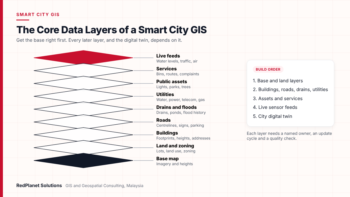
First, a smart city GIS needs a few trusted base layers. Next come work layers, and finally live feeds. So get the base right, because every later layer depends on it.
| Layer | What it holds and why it matters |
|---|---|
| Base map | Imagery and heights from national maps, satellite or drone, so every use case has a common base. |
| Land and zoning | Lots, land use and zoning from land offices and local plans, so planners can check approvals. |
| Buildings | Footprints, heights and addresses from council records, so teams can plan and build 3D models. |
| Roads | Centrelines, signs and parking from LiDAR surveys, so traffic and asset teams share one record. |
| Drains and floods | Drains, ponds and flood history from field surveys, so teams can plan for floods. |
| Utilities | Water, power, telecom and gas networks shared by providers, so road works do not clash. |
| Public assets | Lights, parks and trees from asset registers, so repairs follow risk. |
| Services | Bins, routes and complaints from work systems, so waste and service teams see gaps. |
| Live feeds | Water levels, traffic and air data from sensors, so dashboards and the twin stay current. |
Each layer needs a named owner, an update cycle and a quality check. For example, a building layer that nobody updates after approvals will soon drift out of date. So build data QA and QC into daily work from the start. Do not leave it as a clean-up job for later.
Also, choose open formats where you can. For 3D city models, the OGC CityGML standard is widely used. It describes buildings and city objects in a way that many systems can read.
How Does a Council Move From GIS to a City Digital Twin?
A council reaches a city digital twin in stages, not in one purchase. Each stage should pay off on its own. That way, the plan never depends on the last step to prove its worth.
List and fix base data
List your datasets and owners. Then fix the base map and core layers. Fill gaps with mobile mapping, drone or satellite capture.
One shared GIS
Load clean layers into one central GIS with role-based access. Then publish web maps for each team.
Link daily work
Connect GIS to approvals, repairs, complaints and licences. Field teams can then update records from mobile apps.
Live data and dashboards
Add sensor feeds, such as water levels or traffic counts. Then build dashboards that track smart city goals.
City digital twin
Combine 3D models, live data and simulation. So planners can test floods, new roads or new projects before they act.
Most councils can finish the first two stages with modest effort. However, stages three and four take longer, because they change how teams work. The last stage, an urban digital twin, only pays off when earlier layers are accurate and current.
Platform choice also matters here. For example, Hexagon geospatial software offers strong 3D and real-time views. In contrast, SuperMap GIS combines 2D, 3D and big data analysis in one platform. In the end, the right fit depends on your systems, skills and budget.
Want to know which stage your council has reached and what to do next?
Talk To Our Consultants →How Should Councils Govern Smart City Data Under Malaysian Law?
Good governance means clear owners, shared standards and lawful use of personal data. Without it, a smart city GIS soon turns into another set of silos.
One owner per layer
Each dataset has a named team and officer who keep it accurate.
Shared standards
All teams use the same coordinates, names and metadata, so layers fit together.
Privacy by design
Collect only the personal data a use case needs, and control who can see it.
Personal data is the delicate part. For instance, complaints, licence holders, CCTV and sensor data can all identify residents. Malaysia amended its Personal Data Protection Act in 2024. Then, from 1 June 2025, data controllers had to appoint a data protection officer and report breaches. Data portability rights also began on that date. The Act does not apply to federal and state governments. Even so, councils should ask their legal advisers how it applies to contractors, partners and systems.
A smart city GIS cannot fix unclear roles or missing data deals. For example, teams may not agree who owns which layer. Or utility providers may refuse to share network data. In that case, solve those issues first. Otherwise, the platform will just show the same gaps on a better map.
What Mistakes Slow Down Smart City GIS Programmes?
Most failures come from buying tools before fixing data and roles. The good news is that early planning avoids each mistake below.
Starting with the digital twin
A 3D model on old base data looks good but cannot support real decisions. So build clean layers first.
Dashboards without actions
Teams soon ignore a dashboard that nobody acts on. Instead, link each view to a decision, an owner and a response.
No update cycle
Data captured once and never kept up loses value fast. So plan updates for every layer from day one.
Vendor lock-in
Closed formats make it hard to share data with other agencies. Therefore, ask for open standards and data export in every contract.
Ignoring field teams
Field officers see changes first. Give them simple mobile tools, and their updates will keep the GIS current.
In addition, do not treat smart city GIS as an IT project only. It works best when planning, works and service teams help set priorities from the start.
Where Should Your Council Start With Smart City GIS?
Start where your data is weakest and your daily pain is greatest. Below, common cases match a sensible first step.
Your asset records are on paper or years out of date.
Run a mobile mapping and field capture project, then build an asset layer.
You have good layers, but each team keeps its own copy.
Set up one shared GIS with common standards and role-based access.
Floods or traffic are your most urgent public issue.
Build one focused use case with drain or road layers plus live feeds.
Your core layers are clean, shared and kept up to date.
Plan a 3D model and pilot a digital twin for one district.
Whichever case fits, set clear targets. For example, track approval time, repair backlog or flood response time. Then you can show results to council leaders and in the smart city rating.
Frequently Asked Questions
What is smart city GIS?
Smart city GIS is a map-based system that ties a city’s assets, land records, services and sensor data to their place. It gives every council team one shared map. As a result, teams can plan repairs, check approvals, respond to floods and run services from the same trusted data, not from separate spreadsheets.
What is the Malaysia Smart City Framework?
The Malaysia Smart City Framework is a KPKT guide for local councils, launched in 2019. It has seven parts, such as Smart Mobility, Smart Environment and Smart Digital Infrastructure. It also sets a roadmap from 2019 to 2025. In addition, it named Kuala Lumpur, Johor Bahru, Kota Kinabalu, Kuching and Kulim as pilot cities.
How is a digital twin different from a GIS?
A GIS stores and analyses map data, mostly in 2D. However, a city digital twin adds 3D models, live sensor feeds and simulation. So planners can test scenarios before they act. In practice, a good twin sits on top of an accurate GIS. Learn more on our digital twin page.
Which data layers should a council build first?
Start with the base map, land and zoning, buildings, roads, drains and utilities. These layers support most use cases, from approvals to flood planning. After that, add public assets and service data, such as bins and complaints. Finally, add live sensor feeds for dashboards and alerts.
Does the PDPA apply to smart city GIS data?
It can. Complaints, licence data, CCTV and sensor feeds may identify residents. The PDPA was amended in 2024, and breach reporting and data protection officer duties began on 1 June 2025. Governments have an exemption. But contractors and partners may not, so councils should check their position with legal advisers.
How long does it take to build a city digital twin?
It depends on the state of your data. Councils with clean, shared layers can pilot a twin for one district fairly quickly. But councils with scattered or old records should first focus on data capture. Next, they need a central GIS and linked workflows, because a twin built on poor data cannot support real decisions.
What Is the Practical Path to Smart City GIS in Malaysia?
The path is simple. First, fix the base data. Next, share it through one GIS and link it to daily work. Then add live data. Finally, build a city digital twin once the base is sound.
At RedPlanet Solutions, we see the map as shared city infrastructure, just like roads and drains. So we help councils get the data and ownership right first. Then the digital twin becomes a natural next step, not a risky leap.RedPlanet Solutions
Malaysia’s smart city framework, rating system and national map data all point the same way. So councils that invest in clean, well-run spatial data now will be ready for each later stage. If you want help to judge your starting point, get in touch with our team.
Expert Guides
Related GIS Guides
 GuideHexagon Geospatial Software Explained: GeoMedia, M.App Enterprise and Luciad ComparedHexagon geospatial software explained: GeoMedia, M.App Enterprise and Luciad, their new Octave names, how they fit together and which suits your use case.Read the guide →
 GuideWhat Is GeoServer? How to Publish Spatial Data With OGC StandardsWhat is GeoServer? Learn how this open source map server publishes PostGIS, shapefile and GeoTIFF data as WMS, WFS, WCS and WMTS services.Read the guide →
Plan Your Council's Smart City GIS Roadmap
Our GIS consultants help Malaysian councils review their data and choose the right platform. Then we build a staged path from clean base layers to a working city digital twin.
Talk To Our GIS Consultants
PK Senthilkumar is CEO of RedPlanet Solutions. His work focuses on GIS consulting, network-based GIS for utilities, enterprise GIS modernisation and practical spatial decision-making for organisations operating across Malaysia, India, Australia and international markets.
About RedPlanet Solutions
RedPlanet Solutions (M) Sdn Bhd is a Malaysia-based GIS consulting and geospatial services company and part of RedPlanet Berhad. The company delivers GIS for electric utilities, spatial data collection, drone surveying, mobile mapping and GIS software development to utilities, government agencies, smart cities and private sector organisations across Southeast Asia, the Middle East, Australia and beyond. RedPlanet works across leading commercial and open-source GIS ecosystems, including GE Vernova Smallworld, Esri, Hexagon, SuperMap, QGIS, GeoServer and FME.