
A GIS data quality checklist for utilities tests vendor data against agreed rules before sign-off. It checks that nothing is missing, that lines connect, that values sit in their lists and that assets sit in the right place. Software checks every feature. Then people check a random sample. Failed batches go back for rework and a retest.
- Agree clear pass marks, sample sizes and test methods in the contract before work starts.
- Use the six ISO 19157-1 quality elements so that both sides test the same things.
- Run rule checks on every feature, then use a random sample for what rules cannot see.
- Test location against a separate, more accurate source, not the drawing the vendor traced.
- Reject by batch, log each defect with an ID and retest the whole batch after rework.
What Is GIS Data QA/QC and Why Does It Matter for Utilities?
GIS QA/QC is the set of checks that proves a dataset meets its spec. First, quality assurance stops errors while the data is made. Then quality control finds the errors that slipped through.
For a utility, the test at handover is the last gate. After it, the data goes live. It also feeds outage tools, asset lists, network studies and field crews. So a broken link or a wrong voltage code is no longer just a data fault. Instead, it becomes a fault in daily work.
Most utilities also buy GIS data from outside firms. For example, they pay for data digitisation of paper maps, moves between platforms and field surveys. Each of these needs a test before payment. If there is no test, the utility takes on the defects. It then pays a second time to fix them.
Our piece on data quality in GE Vernova Smallworld GNM shows how bad data spreads. This article, however, looks at handover. In short, it covers what to test, how much to test and when to say yes.
What Pass Marks Should a Utility Set Before Data Capture Starts?
Set the pass marks in the scope of work before capture begins. Each one needs a test, a limit and a clear result if the limit is missed.
Because vague words such as “data shall be accurate” resist testing, state what you measure, what you compare it with and what counts as a pass. For instance, “every service line must link to a customer point and a source” is clear. In addition, a script can check it every time.
Measurable
Each rule has a number or a yes or no result. So two testers would score it the same way.
Referenced
Each test names what it is checked against. For example, that may be the data model, a value list, a drawing or a survey.
Has a consequence
The contract says what happens on a fail. For instance, the batch is rejected, fixed at the vendor’s cost and tested again.
Next, freeze the data model and spec in one signed document. It should list feature classes, required fields, allowed values, link rules, the map grid and metadata fields. If the model changes mid-project, log it as a formal change. Otherwise, you test against a moving target, and that leads to disputes.
In Malaysia, public sector GIS has a national guide. The MyGDI standards work covers feature and attribute codes (MS1759), a metadata standard and dataset quality. So utilities that share data with agencies can match those codes early. As a result, later data exchange needs less rework.
Which Quality Elements Should a GIS Data Quality Checklist Cover?
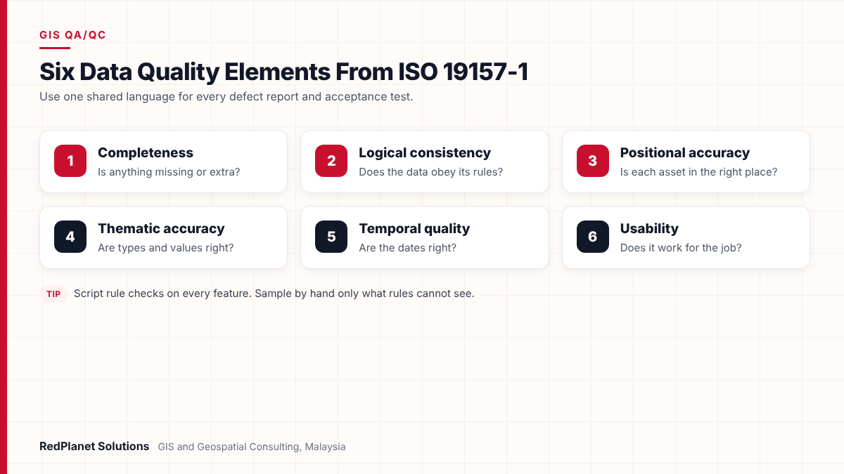
A good checklist covers six elements. These are completeness, logical consistency, positional accuracy, thematic accuracy, temporal quality and usability. They come from ISO 19157-1:2023, the global standard for geographic data quality.
Using these terms gives both sides one shared language. So a defect report can say “logical consistency” and not “the lines look wrong”. The table below links each element to sample tests.
| Element | The question | Example test |
|---|---|---|
| Completeness. | Is anything missing or extra? | Count assets per class. Then look for duplicates. |
| Logical consistency. | Does the data obey its rules? | Run link rules and value list checks. |
| Positional accuracy. | Is each asset in the right place? | Compare a sample with survey points. |
| Thematic accuracy. | Are types and values right? | Check a sample against drawings. |
| Temporal quality. | Are the dates right? | Check build and capture dates. |
| Usability. | Does it work for the job? | Run a full network trace. |
You do not need every test on every job. Still, write down which elements apply and which do not. That choice is part of the spec too.
How Do You Run Topology Checks and Value Tests on a Utility Network?
First, topology checks show that features link up the way the model says. Next, value tests show that each field holds an allowed value. Both should run by script on every feature, not just a sample.
Topology rules worth testing
Most GIS tools also ship with rule sets. For example, ArcGIS Pro topology has line rules such as Must Not Have Dangles and Must Not Overlap. It also has Must Not Self-Intersect and Endpoint Must Be Covered By. Similarly, the QGIS Topology Checker can flag dangles, duplicates and pseudo nodes.
- Dangles: cable ends that stop short of a device. So traces break.
- Overlaps: two lines drawn on top of each other. As a result, lengths are double counted.
- Pseudo nodes: breaks in a line with no real joint. They add clutter but no meaning.
- Loose ends: each cable end should land on a node, switch or transformer. If not, flag it.
Generic rules are only a start. Utilities also need network rules. For instance, phases should carry through, voltage should match across a joint and radial feeders should have no loops. In GE Vernova Smallworld, these checks often run on the network model itself.
Attribute domains and required fields
Attribute domains limit a field to valid values. A coded value domain uses a fixed pick list, while a range domain sets a low and a high limit. So the test is simple. Count each value outside its domain and each empty required field.
Also check how fields relate. For example, a transformer rating should match its type. Likewise, a build date should come before the capture date.
Then check the shapes themselves. The FME GeometryValidator, for instance, finds self-intersections, duplicate points and broken shapes. It can also try to repair them. But count the faults first, because silent repairs hide the vendor’s true error rate.
How Should You Test Location and Choose a Sample Size?
Test location by comparing a sample with a separate source of higher accuracy. Then use random samples for anything a rule cannot check. Also, set the sample size and pass mark in the contract.
The US National Standard for Spatial Data Accuracy (NSSDA) is a common method. It compares your data with a source of higher accuracy. Then it reports the result at the 95% confidence level. It asks for at least 20 check points. In addition, the check data should be collected apart from the data used to build the dataset.
If you compare traced lines with the same drawing the vendor traced, you only prove the tracing was faithful. That says nothing about where the cable is on the ground. So if ground truth matters, budget for survey points, mobile mapping or fresh imagery.
Be clear about what location accuracy means for each source. For example, data traced from a schematic can be right in its links but rough in its place. In that case, set a tight limit against the drawing. Then set a looser limit against the ground. Otherwise, the vendor fails a test the source could never pass.
Sampling for manual checks
Manual checks take time, so most teams sample. For example, ISO 2859-1 sets sampling methods for inspection by attributes. It gives a structured way to pick a sample size. It also sets how many faults a batch may have before it fails.
Whichever method you choose, agree it first. Then pick samples at random across areas, crews and asset types.
Need a separate test of vendor data before you sign it off?
Talk To Our Consultants →Which QA/QC Checks Should Run by Script and Which Need a Person?
Script every check that can be written as a rule. Then run it on the full dataset. Keep people for judgement, such as reading drawings, spotting odd designs and testing real use.
Scripts are also cheap to repeat. So once a rule set exists, it can run on every batch and every resubmission. Tools such as FME suit this well. One workspace can read the vendor’s format and run shape, link and value tests. It then writes a defect report. After that, the native tools in ArcGIS, QGIS or Smallworld confirm the data works in the target system.
The check is a clear rule, such as nulls or dangles.
Script it and test every feature in every batch.
The check compares data with a drawing.
Review a random sample by hand and log each result.
The check needs ground truth.
Send a field team or use survey on planned check points.
The check is about real use, such as tracing.
Ask the users who rely on the data to run test cases.
In addition, keep script and manual results in one defect log. Each defect should have a feature ID, the rule broken, the quality element, a severity and a status. As a result, you can report error rates per batch. So you no longer argue over screenshots.
What Does a Practical GIS Data Quality Checklist Look Like?
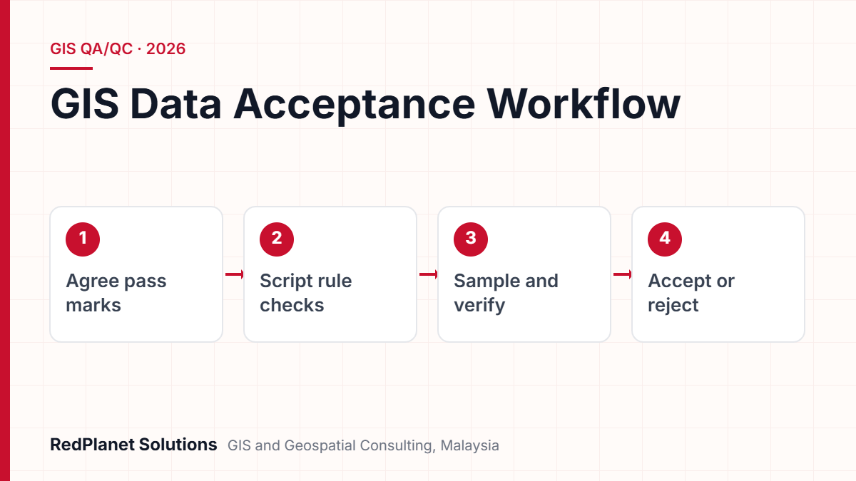
A practical checklist runs in four phases. First comes the work before delivery. Next comes receipt, then testing and finally sign-off.
Use the list below as a start. Then adapt the limits to your own spec.
GIS data acceptance checklist for utilities
Tick each item for every batch. If a required item fails, the batch goes back to the vendor.
Metadata needs its own line, because teams often skip it. ISO 19115-1 sets a schema to describe geographic data. It covers extent, quality, reference systems and distribution. At the very least, record lineage, capture method and date. Then future users know how far to trust the data.
What Are the Most Common Mistakes in GIS Data Acceptance?
The most common mistakes are testing too late and testing against the wrong source. Another is letting repairs hide the real error rate. In each case, data passes on paper but fails in the field.
Testing only at the end
One test after a year of work finds faults when they cost most. So test a pilot batch early, then every batch after it.
Checking against the vendor's source
If you check location against the traced drawing, you miss real errors. Instead, use a separate source where location matters.
Repairing before counting
If repair tools run first, the true error rate is lost. As a result, you lose the proof you need to reject a batch.
No agreed sample method
Picking samples by eye after delivery invites disputes. So agree random selection and sample size before work starts.
Skipping real use tests
Data can pass every rule and still fail a trace. Therefore, always run the tasks the business will use.
There is also a softer mistake. Some teams treat QA/QC as the vendor’s job alone. The vendor should run its own checks. But the client still needs a separate test, because otherwise nobody tests the tester.
In our view, the cheapest defect is the one caught in the first batch. Once bad data reaches production, every system downstream pays for it.RedPlanet Solutions
How Should Utilities Write QA/QC Into Vendor Contracts?
Write QA/QC into the contract as clear deliverables with a set process. That way, the vendor knows the tests, limits and rework terms before pricing the job.
Specify
Attach the data model, value lists, link rules and pass marks as contract schedules.
Pilot
First, ask for a small pilot batch. Then test it in full before main capture starts.
Deliver in batches
Split delivery by area or feeder. Each batch comes with metadata and the vendor’s own QA report.
Test and log
The client or a third party runs the tests. Then it issues a defect log within an agreed window.
Rework and retest
The vendor fixes and resends the whole batch. Then the full rule set runs again.
Also, tie payments to accepted batches, not delivered ones. In addition, ask the vendor to send its own defect log with each batch. If its numbers differ a lot from yours, its own checks may be weak.
Finally, think about a third party for large jobs, such as a data migration. A third party has no stake in the result. It can also reuse rule sets across vendors. For example, our GIS QA/QC services cover topology checks, value checks and error detection.
Frequently Asked Questions
What is a GIS data quality checklist?
It is a list of tests a utility runs on GIS data before it accepts it. It checks for missing data, broken links, wrong values, wrong locations, old dates and missing metadata. Each test has a method, a limit and a pass or fail result. So the decision to accept rests on proof, not opinion.
What is the difference between GIS QA and GIS QC?
QA stops errors while the data is made. For example, it uses specs, training and capture rules. QC, by contrast, finds errors in the finished data. It uses scripted rules and sample checks. Utilities need both. The vendor runs QA during capture. Then the client or a third party runs QC before sign-off.
How many check points do I need for a location test?
The US National Standard for Spatial Data Accuracy asks for at least 20 check points. It reports results at the 95% confidence level. The points should come from a separate source of higher accuracy. Also, spread them across the whole area. Large or varied areas may need more, so agree the number in the contract.
Which topology rules matter most for utility networks?
The most useful rules catch link failures. These include dangles, overlaps, duplicates, pseudo nodes and cable ends that do not land on a device. Utilities should also add network rules. For instance, phases should carry through and radial feeders should have no loops. Generic shape rules cannot see those errors.
Can FME be used for GIS QA/QC?
Yes. FME reads most GIS formats. It can then run shape, value and link tests in one workspace and write a defect report. Its GeometryValidator finds faults such as self-intersections and duplicate points. Many teams pair FME with the topology tools in their main GIS. See our FME services.
Should we test every feature or only a sample?
Test every feature with scripted rules, because they are cheap to run and repeat. Use samples only for checks that need a person or a site visit. For example, that means comparing values with drawings or measuring location against survey points. Also, agree the sample method with the vendor first, so that you avoid disputes later.
What Should Utilities Do Next to Improve Data Acceptance?
First, start with the spec. If your contracts lack clear pass marks per element, fix that before the next tender. Then build a rule set once and reuse it on every batch.
Define
Freeze the model, value lists and limits. Then map them to the ISO 19157-1 elements.
Script
Run shape, link and value rules on every feature in every batch.
Sample
Check type and location on a random sample against a separate source.
Decide
Accept or reject each batch based on one shared defect log.
A sound GIS data quality checklist protects every system that relies on the GIS. So the effort at handover is small next to the cost of fixing a live network later. If you want a second view on vendor data, or help writing clear tests, get in touch with our team.
Expert Guides
Related GIS Guides
 GuideElectric Network Model Validation: A Data Checklist for Go-LiveElectric network model validation checklist for OMS and ADMS go-live: connectivity, phasing, open points, customer links, CIM exports and sign-off.Read the guide →
 GuideWhat Is FME? How GIS Teams Run FME GIS Data Migration and Spatial Data IntegrationWhat is FME and how does an FME GIS data migration work? Learn FME Form, FME Flow, transformers, CAD to GIS, Smallworld and Esri moves, plus QA steps.Read the guide →
 GuideMobile GIS Data Collection for Utilities: Field Workflows That Cut ReworkMobile GIS data collection for utilities: form design, GNSS accuracy, offline sync, photo standards and QA at source that cut field rework.Read the guide →
Get a Second Check Before You Accept GIS Data
RedPlanet Solutions runs GIS QA/QC for utilities. We test topology, values and location, and we report on acceptance across Smallworld, ArcGIS, QGIS and FME. Talk to us about your next delivery.
Talk To Our GIS Consultants
PK Senthilkumar is CEO of RedPlanet Solutions. His work focuses on GIS consulting, network-based GIS for utilities, enterprise GIS modernisation and practical spatial decision-making for organisations operating across Malaysia, India, Australia and international markets.
About RedPlanet Solutions
RedPlanet Solutions (M) Sdn Bhd is a Malaysia-based GIS consulting and geospatial services company and part of RedPlanet Berhad. The company delivers GIS for electric utilities, spatial data collection, drone surveying, mobile mapping and GIS software development to utilities, government agencies, smart cities and private sector organisations across Southeast Asia, the Middle East, Australia and beyond. RedPlanet works across leading commercial and open-source GIS ecosystems, including GE Vernova Smallworld, Esri, Hexagon, SuperMap, QGIS, GeoServer and FME.