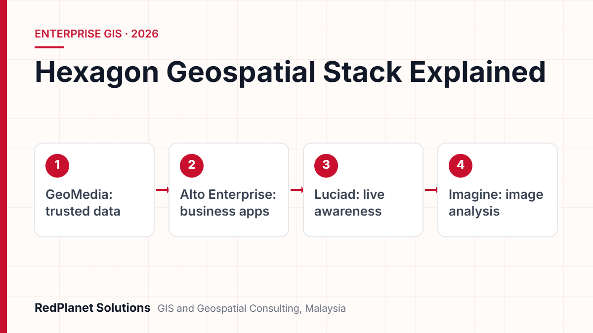
Hexagon geospatial software has three main parts. First, GeoMedia is desktop GIS for data and analysis. Next, M.App Enterprise, now called Octave Alto Enterprise, builds web, mobile and dashboard apps. Then Luciad, now Octave Alto, shows live 2D and 3D data. Since May 2026, all three belong to Octave, a firm spun off from Hexagon.
- On 28 May 2026, Hexagon’s geospatial tools moved to Octave, so many now carry new names.
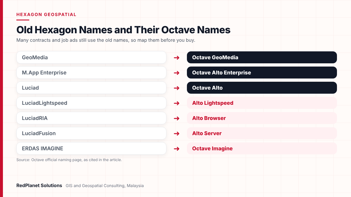
- GeoMedia is now Octave GeoMedia, M.App Enterprise is now Octave Alto Enterprise and Luciad is now Octave Alto.
- First, GeoMedia suits GIS experts who build, check and study trusted data on the desktop.
- So Alto Enterprise and the Alto parts then put that data into apps, dashboards and live views for wider teams.
- Most buyers use two or more products, so plan data, links and licences together from day one.
What is Hexagon geospatial software in 2026?
Hexagon geospatial software is a family of GIS, imaging and live map tools that grew up inside Hexagon AB. But in 2026 they belong to Octave, the software firm that Hexagon spun off. As a result, most of them now carry Octave names.
So the old names still matter, but they now point to a new vendor. The dates are on Hexagon’s investor page on the Octave split. First, shareholders backed the plan in April 2026. Then the split closed on 28 May 2026. Also, Octave now groups Geospatial and Infrastructure with Safety, ETQ, Bricsys and other units.
Still, for buyers, the core tech has not changed. However, product pages, support sites and quotes now use the new names. If you read an old tender or plan, you need a key to the names. So this guide gives you that key. Then it compares the three tools that matter most for firm-wide GIS.
Also, for an overview of how we back this stack, see our Hexagon GIS services. Then the rest of this guide stays on the products and how to pick between them.
What are the new Octave names for GeoMedia, M.App Enterprise and Luciad?
Each old Hexagon product now has an Octave name, while the Luciad parts moved under the Alto brand. So the table lists the names most GIS teams will meet, taken from Octave’s official naming page.
| Old Hexagon name | Octave name in 2026 |
|---|---|
| GeoMedia | Octave GeoMedia |
| M.App Enterprise | Octave Alto Enterprise |
| Luciad | Octave Alto |
| LuciadLightspeed | Alto Lightspeed |
| LuciadRIA | Alto Browser |
| LuciadFusion | Alto Server |
| LuciadCPillar | Alto Universal |
| ERDAS IMAGINE | Octave Imagine |
Overall, two points stand out. First, M.App Enterprise and Luciad now share one name, Alto. Octave says it also folded ERDAS APOLLO and two other lines into Alto. Second, GeoMedia keeps its own brand. That shows it still has its role as the main desktop tool.
So in this guide we use both names where it helps. For example, we write “M.App Enterprise (now Alto Enterprise)” because many contracts and job ads still use the old term.
What does GeoMedia do and who uses it?
GeoMedia is desktop GIS for building, checking and studying trusted map data. Octave says it brings complex data into one place. Also, its users include GIS analysts, planners, engineers and state bodies.
Its key strength is data access, since it links to databases, GIS files and web services. Also, it reads that data as it is, with no need to convert it. As a result, teams can work across many sources at once.
Core tasks
- First, spatial queries, network models and analysis across datasets.
- Also, maps and views in both 2D and 3D.
- Next, data checks against your own rules.
- Finally, maps and reports, plus data ready to publish on the web.
Tiers and add-ons
GeoMedia comes in three tiers: Essentials, Advantage and Professional. In addition, add-ons extend it for set jobs. For instance, Transportation Manager models road and rail lines. Next, Mapping Manager helps with map output. Then GeoMedia Objects gives coders tools for custom apps.
So GeoMedia is the right base when data quality matters more than reach. But it is not built to serve hundreds of casual users. Instead, teams publish its output through WebGIS or link it to Alto Enterprise.
What is M.App Enterprise, now Octave Alto Enterprise?
M.App Enterprise, now named Octave Alto Enterprise, is a platform for map apps that mix maps, dashboards, forms and workflows. Also, Octave says it is the same platform with a new name.
But its users go well past GIS experts. For example, office planners, ops teams, field crews and IT staff all use it. So it is often where non-GIS staff first meet map data.
App building
First, build web, desktop and mobile apps that mix maps, charts and forms.
Map dashboards
Also, make 2D and 3D dashboards with BI widgets, spatial models and trend checks.
Offline field work
Crews capture and edit data with no signal, then sync once back online.
Role-based workflows
Set standard tasks, then check data and limit access by role.
Wide data access
Also, link files, databases, web services, ERP and live feeds, mostly as they are.
One admin console
Finally, manage users, roles and tenants, and track use from one place.
Also, you can run it on your own servers or as a hybrid. Since tenants and roles sit in one console, one install can serve several teams. For instance, a city could run apps for planning, permits and repairs on the same base.
What is Luciad, now Octave Alto, and where does it fit?
Luciad, now called Octave Alto, is a set of tools for fast, live map views. Also, Octave aims it at defence, command and control, aviation, transport, cities and grids.
Unlike GeoMedia, Luciad is mostly a kit of parts that coders build into custom systems. Also, the core tech did not change with the new name, according to Octave’s Alto product page. So here are the main parts.
- First, Lightspeed, once LuciadLightspeed, runs 2D, 3D and time-based apps on desktops and on board.
- Next, Browser, once LuciadRIA, is a JavaScript kit for rich apps in the web browser.
- Also, Universal, once LuciadCPillar, is a kit for C++, C# and Android.
- Finally, Server, once LuciadFusion, tiles large data and serves it as WMS, WMTS, WFS-T, WCS, CSW and 3D Tiles.
Luciad is also known for large, fast data. For instance, Alto Server reads more than 200 formats. For example, these include point clouds, 3D meshes and weather data. It also streams tiled data over weak networks. In addition, Alto supports military symbols and sensor fusion, so it has a strong defence base.
But the trade-off is effort, because Luciad projects need coding, not just set-up. Therefore, budget for coders who know the kits, or for a partner that does.
How do GeoMedia, M.App Enterprise and Luciad compare side by side?
In short, GeoMedia builds and studies trusted data. Then Alto Enterprise puts it into business apps. Finally, Luciad shows it live. So the table sets them side by side.
| Point | GeoMedia | Alto Enterprise | Luciad (Alto) |
|---|---|---|---|
| Main job | Data and analysis | Apps and dashboards | Live 2D and 3D views |
| Users | GIS analysts | Ops and field teams | Coders and control rooms |
| Where it runs | Desktop, plus WebGIS | Own servers or hybrid | Own servers, cloud or hybrid |
| Effort | Set-up and data models | App design | Coding |
These tools also work well together. For example, a common plan starts with analysts who keep data in GeoMedia. Next, Alto Enterprise opens it to field and office users. Then Alto parts feed a control room or a digital twin. So each layer adds users but keeps one master copy of the data.
Octave Imagine, once ERDAS IMAGINE, often sits beside all three, since it turns satellite, air and drone images into map layers. Then the other tools use those layers.
Which Hexagon product suits smart city, utilities, defence and agriculture projects?
Overall, the best fit depends on who uses the system and how fast the data changes. So use this guide as a start, then test it on your own work.
A smart city that has many teams and also wants a twin.
Alto Enterprise for team apps, then Alto parts for 3D and live data.
A utility that keeps network records and also asset data.
GeoMedia for data quality, then Alto Enterprise for field crews.
Defence or public safety teams that also need one live picture.
Luciad, with Lightspeed, Browser and Server.
Farms or plantations watched from images.
Octave Imagine for crops, then Alto Enterprise for field checks.
Smart city
City projects often need many users, many teams and a 3D view. In Malaysia, for example, the housing and local government ministry set out the Malaysia Smart City Framework. Its goal is to link smart city work across all three tiers of government, so local councils tend to prefer shared platforms over lone tools. So, to see how these layers fit, read about our smart city GIS services.
Utilities
First, power and water firms care most about correct network data. So GeoMedia helps, because it does checks and analysis well. Also, Alto Enterprise helps crews inspect assets offline. But if your main network model runs on another platform, Hexagon tools often play a side role. For that wider view, also read about our electric utility GIS.
Defence and live awareness
Here Luciad is the clear choice, because it supports military symbols, sensor fusion and time-based views. It also streams heavy 3D data. In addition, GeoMedia has an add-on for high-volume vector capture to MGCP specs.
Farms and plantations
For example, Octave lists crop health and soil checks, with NDVI, among Imagine’s uses. Then Alto Enterprise can send results to field teams for ground checks. Also, see our agriculture GIS services. In addition, read about our work with satellite imagery.
Not sure which mix fits your project? If so, our team can match your needs to the right tools.
Talk To Our Consultants →How does licensing work for Hexagon geospatial software?
Licences differ by product, so treat them as part of the design. Also, Octave does not list prices on its product pages. Instead, quotes come through sales or resellers.
In the past, desktop GeoMedia used network licences, so several users could share a pool of seats from a licence server. Also, Hexagon’s own guide for GeoMedia 2018 and 2020 sets out this shared model. But platform and kit products often use other terms, such as server or runtime licences. So check the current model for each product before you size a project.
- Count daily and casual users apart, since they need different licences.
- Also, ask how test and live setups are licensed.
- Check runtime and resale terms if you build an app on a kit.
- Then ask how the Octave name change affects your current terms.
If you only need simple web maps for a few users, a full Hexagon stack may be too much. In that case, open source tools such as QGIS and GeoServer can cover light work. But the Hexagon tools pay off when you need strong data control, many linked sources or live 3D at scale.
What should you plan for when rolling out Hexagon geospatial software?
First, good projects start with the data and the users, not the software. Then they roll out in phases, so each layer proves its worth first.
Also, data moves are often the largest hidden task. For example, moving old CAD or GIS layers into a clean database takes time. So it helps to automate that work with tools such as FME. Also, our team handles this step for large GIS projects as part of data migration.
Buying by brand
If you pick a tool before you know your users, you end up with the wrong licence mix.
Ignoring the new names
Because old names in tenders can confuse buyers and support, use both names in your specs.
Skipping data cleanup
If data is poor, live dashboards just spread errors faster.
Underrating kit work
Luciad parts need coders, so plan the skills and time for custom code.
No link plan
Links to ERP, asset and SCADA systems set long-term value, so design them early.
Hexagon rollout checklist
So use these phases to keep scope and risk in check.
Frequently Asked Questions
Is Hexagon Geospatial still part of Hexagon?
No, because Hexagon’s geospatial tools moved to Octave, a firm spun off from Hexagon. The split then closed on 28 May 2026. Since then, Octave has traded on Nasdaq Stockholm and Nasdaq New York. Also, GeoMedia, M.App Enterprise and Luciad live on under Octave names. But the core tech stays the same, so current users can keep working as before.
What is M.App Enterprise called now?
M.App Enterprise is now called Octave Alto Enterprise. Octave says it is the same platform with a new name. It still builds web, desktop and mobile apps with maps, dashboards and forms. Also, it has role-based workflows. Field crews can capture data offline, then sync when they are back online.
What is the difference between GeoMedia and Luciad?
GeoMedia is desktop GIS for keeping, checking and studying trusted map data. But Luciad, now Octave Alto, is a set of kits and servers for live 2D and 3D views. So GIS analysts mostly set up GeoMedia. However, Luciad projects usually need coders who build custom apps for each mission.
Is Luciad only for defence?
No. Luciad is strong in defence because it supports military symbols and sensor fusion. However, Octave also aims Alto at aviation, transport, cities and utilities. So any team that needs to see large, fast or 3D data in one live picture can consider it. For example, that includes digital twin and control room projects.
Can GeoMedia, M.App Enterprise and Luciad work together?
Yes. For example, a common plan uses GeoMedia to keep trusted data. Then Alto Enterprise brings apps to office and field users. Finally, Alto parts show live 3D views. All three read many data sources as they are, so they can share one master copy. Also, for help with this, see our Hexagon GIS services.
How is Hexagon geospatial software licensed?
It varies by product, so there is no single model. In the past, desktop GeoMedia used shared network licences from a licence server. But platform and kit products follow their own server or runtime terms. Also, Octave does not post prices online, so quotes come through sales or resellers. Therefore, confirm the terms for each setup before you size a project.
Which Hexagon geospatial product should you choose?
Choose GeoMedia for trusted data, Alto Enterprise for reach and Luciad for live views. Also, most mature teams use more than one. Then they link them through one shared data model.
Overall, the move to Octave changes names, not core tech. Even so, it is a good time to review licences, design and plans. In addition, make sure new specs use the new names next to the old ones.
So at RedPlanet, we never ask which Hexagon tool is best. Instead, we ask which users need which data, how fast, and how the parts will share one source of truth.RedPlanet Solutions
So if you plan a new rollout or an upgrade, ask us for a practical review and get in touch with our GIS team.
Expert Guides
Related GIS Guides
 GuideSmart City GIS in Malaysia: Use Cases, Data Layers and a Digital Twin RoadmapSmart city GIS Malaysia guide for local councils: use cases, core data layers, MSCF and PDPA governance, and a staged roadmap to an urban digital twin.Read the guide →
 GuideQGIS vs ArcGIS for Utilities: Which Fits Your Network Data Workflow?QGIS vs ArcGIS for utilities: compare licensing, ArcGIS Utility Network modelling, editing, data formats, integration and hybrid setups to pick your fit.Read the guide →
 GuideSuperMap 3D GIS Explained: iDesktopX, iServer and Real Use CasesA plain guide to SuperMap 3D GIS: iDesktopX, iServer, S3M, BIM and point cloud tools, how it compares with Esri and QGIS, and how licensing works.Read the guide →
Plan your Hexagon and Octave GIS roadmap with us
RedPlanet Solutions helps utilities, cities, plantations and state bodies pick and roll out GeoMedia, Alto Enterprise and Luciad, so each tool fits its users. Then tell us your goals, and we will suggest a practical design.
Talk To Our GIS Consultants
PK Senthilkumar is CEO of RedPlanet Solutions. His work focuses on GIS consulting, network-based GIS for utilities, enterprise GIS modernisation and practical spatial decision-making for organisations operating across Malaysia, India, Australia and international markets.
About RedPlanet Solutions
RedPlanet Solutions (M) Sdn Bhd is a Malaysia-based GIS consulting and geospatial services company and part of RedPlanet Berhad. The company delivers GIS for electric utilities, spatial data collection, drone surveying, mobile mapping and GIS software development to utilities, government agencies, smart cities and private sector organisations across Southeast Asia, the Middle East, Australia and beyond. RedPlanet works across leading commercial and open-source GIS ecosystems, including GE Vernova Smallworld, Esri, Hexagon, SuperMap, QGIS, GeoServer and FME.