Establishing a Greenfield enterprise GIS environment for electrical network and land base data, supported by enterprise GIS product implementation, SAP integration and SCADA integration.
| Country | Project Type | Scope | Integrations |
|---|---|---|---|
| India | Greenfield EGIS | Network + Land Base | SAP · SCADA |
Overview
An Electric Utility in India required a Greenfield Enterprise GIS (EGIS) implementation to establish, from the ground up, a geospatial environment capable of managing its complete electrical network assets and land base. As a distribution utility operating without an existing enterprise GIS foundation, the organisation needed a purpose-built spatial environment that could support asset management, network planning, operational integration with SAP business processes and real-time SCADA connectivity.
RedPlanet Solutions was engaged to design and deliver the complete GIS solution framework across all phases of the project. The scope covered survey data import, Enterprise GIS product suite configuration and customisation, SAP integration for business process management, and SCADA integration for operational control. This was a true Greenfield engagement — there were no legacy GIS records to migrate. The project began with field survey and data capture, building the spatial environment from first principles.
Project Context
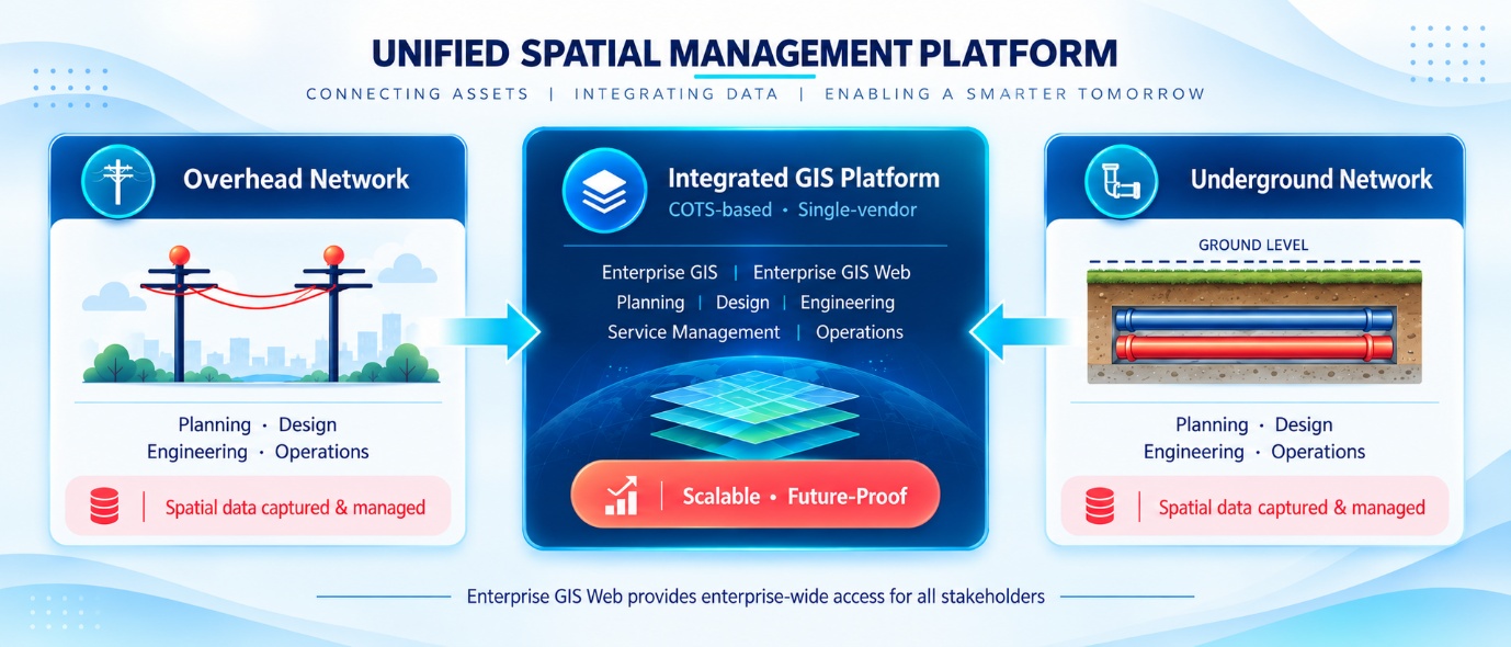
The utility’s decision to implement a Greenfield EGIS environment reflected a strategic commitment to geospatial-enabled asset management and enterprise integration. Prior to the project, the organisation managed its electrical network and land base information through non-spatial systems and manual records. The EGIS project was designed to bring all of this information into a single, structured geospatial environment connected to enterprise business processes.
The full implementation scope included:
- Survey and import of the complete electrical network — including all network assets from substation to consumer connection
- Survey and import of the organisation’s full land base data
- Implementation of enterprise GIS products across the Enterprise GIS suite
- Reengineering of existing SAP-centric business processes to incorporate GIS as a core data source
- Data digitisation and validation frameworks to ensure spatial data quality
- SAP integration to connect GIS with enterprise asset and maintenance workflows
- SCADA integration to connect the GIS network model with the operational control environment
RedPlanet Solutions’ Scope
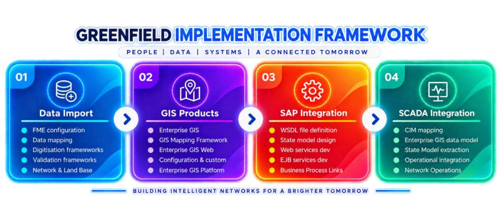
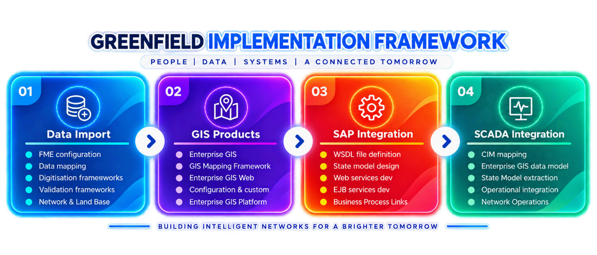
RedPlanet Solutions developed a structured solution framework for each phase of the Greenfield EGIS project, organised across four primary workstreams.
1. Data Import
The data import workstream established the technical foundations for loading survey data into the GIS environment. This included configuring FME for data extraction, transformation and loading, defining data mapping specifications, and building digitisation and validation frameworks to process field survey data consistently and accurately. These frameworks were the mechanism through which all electrical network and land base survey data was ingested, validated and loaded into the enterprise GIS database.
2. Enterprise GIS Product Suite
The Enterprise GIS product suite — including Enterprise GIS, GIS Mapping Framework and Enterprise GIS Web — was configured and customised to meet the utility’s specific operational requirements. Enterprise GIS provided the core desktop GIS environment for network asset management and planning. GIS Mapping Framework extended mapping and visualisation capabilities. Enterprise GIS Web provided browser-based access to GIS information for stakeholders who needed visibility of network data without the need for a full desktop GIS installation.
3. SAP Integration
SAP integration was a major component of the project. The integration connected the EGIS environment with the utility’s existing SAP-based business processes for asset management, work order management and maintenance planning. The scope included WSDL file definition, State Model design, and the development of web services and EJB services to support bi-directional data exchange between GIS and SAP.
4. SCADA Integration
SCADA integration connected the GIS network model with the organisation’s operational control system. This involved CIM (Common Information Model) mapping of the Enterprise GIS data model and integration of network model extraction into the State Model, enabling real-time operational data to be associated with geospatial network records and supporting the exchange of network topology information with the SCADA environment.
Technology Stack
- Enterprise GIS Platform (desktop · web · mobile) — core utility GIS environment including GIS Design Manager and Enterprise GIS Web
- Geospatial Analysis Tools — spatial network analysis, asset querying, proximity analysis, network tracing and geospatial data visualisation
- Enterprise Gateway · Diagnostics · Google Maps — operational and visualisation tools
- FME Desktop & Server — data integration and transformation
- PostgreSQL — database platform
Conclusion
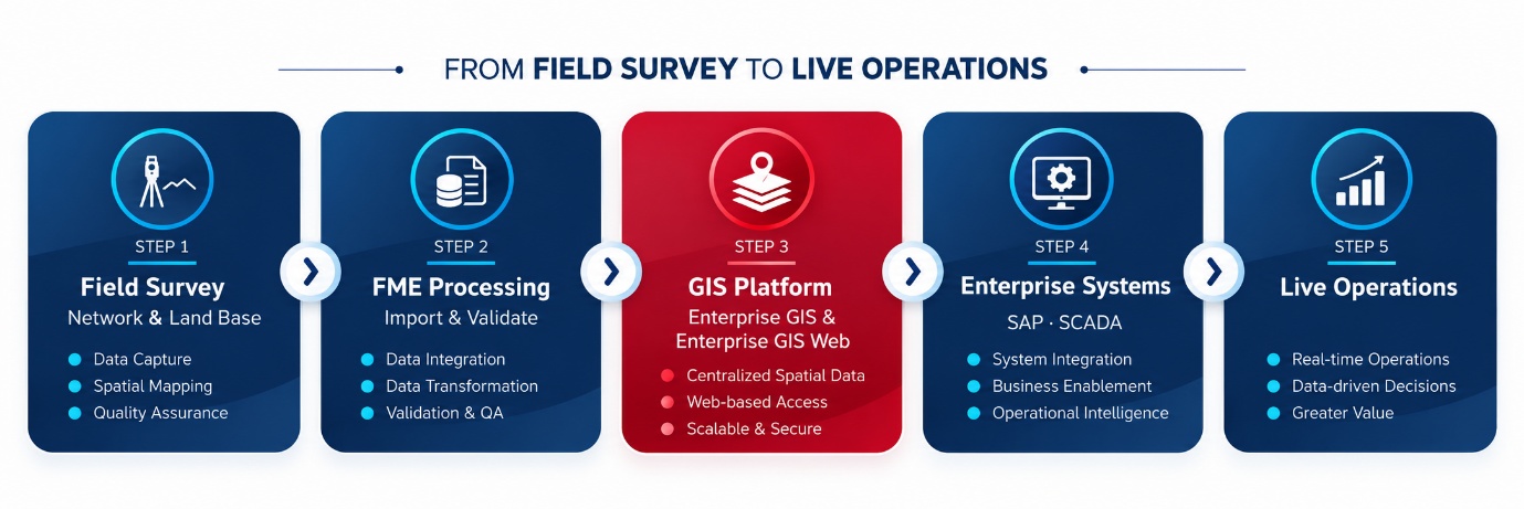
The Greenfield EGIS project delivered a complete enterprise GIS environment for an Electric Utility in India, built entirely from field survey data through to live, integrated operations. RedPlanet Solutions’ scope covered the full delivery lifecycle — from data import frameworks and Enterprise GIS product implementation, through SAP business process integration and SCADA network model connectivity. The project demonstrated a structured, phased approach to building a full-scale enterprise GIS environment in an organisation with no prior GIS foundation, and established a spatial platform capable of supporting the utility’s long-term asset management, planning and operational requirements.