
Mobile GIS data collection for utilities cuts rework when quality is built into capture. First, use attribute domains instead of free text. Next, match GNSS accuracy to each task and store accuracy data with every point. Also, design for offline work, set photo standards and review records daily. Then check data before it enters the network model.
- Most field rework comes from free text, unknown GNSS accuracy and records nobody checked on site.
- Attribute domains, conditional visibility and calculated fields cut typing errors at the point of capture.
- Phone GNSS suits inspections, but new and buried assets need sub-metre or RTK receivers.
- Design every workflow to run offline, because power line routes and plantations can lack signal.
- QA on the device, in daily review and before loading keeps field data fit for the network model.
What is mobile GIS data collection for utilities?
Mobile GIS data collection means crews capture asset locations, details and photos on a phone, tablet or rugged handheld. Then the app syncs those records into the utility’s GIS. If the app checks each record in the field, it reaches the office ready to use.
For electric, water and gas networks, the scope is wide. Crews record poles, transformers, valves, meters, manholes and cable routes. They also log condition, defects and trees that grow too close to lines. Because each record feeds planning, outage response and the asset register, a weak record costs money twice. First, you pay for the site visit. Then you pay again to fix the record in the office.
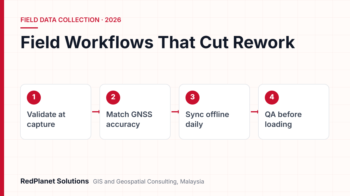
This guide looks at workflow design rather than hardware. Our field data collection services page explains how RedPlanet runs surveys from start to finish. Here, we focus on the design choices that decide whether a crew must go back to site.
Where does rework in utility field data come from?
Most rework comes from three places. First, crews type free text. Next, they save points without a known accuracy. Finally, nobody checks the record before the crew leaves site. Each one is a design flaw, so each one can be designed out.
Free text is the most common cause. For example, one inspector types “wood”, another types “timber”, and a third leaves the field blank. As a result, the asset team cannot filter poles by material without a clean-up job. Likewise, a point from an unknown GNSS fix looks exact on screen. But nobody can tell if it sits within one metre or ten.
Missing photos and blank answers also tend to surface weeks later, in back-office review. By then, the crew has moved to another district. So a five-minute fix on site turns into a half-day revisit. The rest of this guide tackles each cause in turn.
Limit the input
Use pick lists, ranges and defaults so crews choose valid values instead of typing them.
Keep the evidence
Store GNSS accuracy, fix type and photos with each feature, so reviewers can trust or reject it.
Check before leaving
Check records on the device and at the end of each shift, while the asset is still in front of the crew.
How should you design forms, domains and validation at capture?
Design the form from the data model outwards. First, start with the enterprise GIS schema. Next, apply attribute domains to each field that holds a category. Then build a short form that shows only the questions each asset needs.
Use domains, not free text
Attribute domains are rules stored in the geodatabase. They limit what a field can hold. For example, a coded value domain limits a field to a list, such as pole material. In contrast, a range domain limits a number to a set minimum and maximum, such as pole height. Because the rule lives in the database, every app that edits the layer also follows it.
Show less, calculate more
Modern form tools support conditional visibility and calculated fields. For instance, in ArcGIS Field Maps, a question can appear only when an earlier answer makes it relevant. Calculated expressions can also fill in the inspection date, the user’s name, or the region a point falls in. So crews answer fewer questions and make fewer typing errors.
There is one trap, though. Esri’s own guidance warns that a hidden form element loses its value. So test every branch of the form on a real device before rollout, not just in the desktop designer.
- Required fields: mark only what the asset register truly needs. Otherwise, crews type dummy values just to get past the form.
- Defaults: set a sensible default for the common case, such as asset status “In service”.
- Groups: split long forms into parts, so crews see identity, condition and defects in turn.
- Related records: store repeat inspections in a related table, rather than as new copies of the asset.
Which GNSS accuracy does each utility task need?
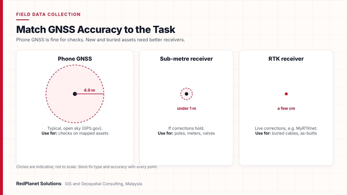
Match the receiver to the decision the data supports. Phone GNSS suits condition checks on assets already mapped. However, new assets, buried networks and anything that drives design or digging need a sub-metre or RTK receiver.
The US government’s GPS performance page says GPS phones are typically accurate to within a 4.9 m radius under open sky. That figure gets worse near buildings, bridges and trees. In contrast, high-end users with dual-frequency receivers or correction systems can get real-time positions within a few centimetres.
| Option | Typical accuracy | Best for | Watch out |
|---|---|---|---|
| Phone GNSS. | Metres, and worse under trees. | Checks on mapped assets. | Do not use it for new assets. |
| Sub-metre receiver. | Below one metre, if corrections hold. | Poles, meters and valves. | It needs Bluetooth set-up. |
| RTK receiver. | A few centimetres with live corrections. | Buried cables, pipes and as-builts. | It needs a stable data link. |
Malaysia has a real edge here. JUPEM, the Department of Survey and Mapping Malaysia, runs MyRTKnet. It is a national network of always-on reference stations that streams live corrections. Its coordinates use the national datum, GDM2000. So set the right datum transformation in your app. Esri’s high-accuracy data collection guide warns that a missing or wrong transformation makes points sit away from existing data.
Also, keep the metadata. Field Maps can write horizontal accuracy, PDOP, fix type, satellite count and correction age to fields on point layers. Reviewers can then filter out any point saved without a fixed solution.
How does offline GIS sync work when crews lose signal?
Offline GIS lets crews download a set map area and work on the device with no signal. Then they sync their edits when they reconnect. So plan offline areas before go-live, because they decide what crews can see and edit.
The main app families both work this way. In ArcGIS Field Maps, authors set offline map areas in Field Maps Designer, and the layers must have sync turned on. Edits then stay on the device until the worker syncs. Similarly, QFieldCloud packs offline layers into one GeoPackage for QField. Later, it sends back only the changed features and values.
Mobile coverage in Malaysia is better than many crews assume, but it is uneven. Under JENDELA Phase 1, 4G reached 96.92% of populated areas by the end of 2022. However, that figure tracks where people live. Power line routes, plantations, forest reserves and hills can still lose signal. So design every workflow to run fully offline, and treat signal as a bonus.
- Set offline areas by feeder, zone or work package, rather than by whole state.
- Sync at least once a day, so a lost device costs one day of work at most.
- Push all pending edits before you change the schema. Otherwise, field copies fall out of step.
- Skip attachment downloads for crews who only add new assets, so packages stay small.
What photo and attribute standards should field crews follow?
Write a short capture standard and build it into the form. Each photo needs a clear purpose, the same framing and a link to one asset. That way, reviewers can check details without a site visit.
Photos do most of the work in QA. For example, a reviewer can confirm a pole’s material, cross-arm type and tag number from one good picture. But a blurry close-up of rust proves very little. Tropical weather adds its own problems, because rain, glare and damp on the lens all spoil images. So the standard should tell crews when to retake a shot.
Field capture standard
Adapt this list to your asset classes, then use it in crew briefings.
Finally, keep field names and units the same as the enterprise schema. If they differ, every sync needs a mapping step, and mapping steps are where values go missing.
How do you run QA at source and load data into enterprise GIS?
Run QA in three layers. First, set rules on the device. Next, add a supervisor review each day. Then run automated checks before data enters the enterprise GIS. Each layer catches what the last one missed, and errors cost less to fix the earlier you find them.
- On the device: domains, required fields and accuracy limits block the most common errors as crews capture.
- Daily review: a supervisor checks a sample of records, photos and GNSS data. Then failures go back to the same crew while they are still nearby.
- Before loading: automated checks test topology, links and attributes against the network model. After that, a controlled load moves data into the system of record.
That last step matters most for utilities, because the target is often a connected network model, not a flat layer. For example, a new service cable must link to the right transformer, and a valve must sit on a main. Our GIS QA/QC services apply these rules before field data reaches platforms such as GE Vernova Smallworld or Esri. Where old records also need cleaning, we pair this with GIS data migration.
In our experience, the cheapest place to fix a field record is beside the asset. Every step it travels after that, from tablet to supervisor to network model, adds to the cost of the fix.RedPlanet Solutions
Want a second opinion on your forms, accuracy rules or sync design before rollout?
Talk To Our Consultants →Which mobile GIS apps suit utility asset inspection work?
Choose the app that fits your enterprise GIS and your workflow, not the longest feature list. Most utilities pick from three groups. These are Esri apps, the open source QGIS family, or a utility platform with inspection and outage tools built in.
ArcGIS Field Maps
Esri’s mobile app for maps, data capture and inspections on ArcGIS feature layers. It also offers offline map areas, smart forms and external GNSS support, so it suits Esri-based utilities.
QField with QFieldCloud
A free, open source app under the GPL licence. It runs QGIS projects on Android, iOS and Windows, while QFieldCloud handles sync. So it suits teams that already work in QGIS.
ATLAS, supplied by RedPlanet
A utility asset management and mobile GIS platform for pole inspections, vegetation management, leak surveys and outage data. It also offers offline vector maps, tracing, audit trails and crew tracking.
If your system of record is ArcGIS Enterprise or ArcGIS Online.
ArcGIS Field Maps, set up on your existing feature services.
If you run QGIS and PostGIS and want to avoid per-user licences.
QField, with QFieldCloud or desktop sync.
If crews need inspections, outage views and tracing in one app.
ATLAS, supplied by RedPlanet.
If your network model sits in Smallworld or another utility GIS.
Any of the above, plus a tested link into the network model.
No app fixes a weak data model. So if your schema has mixed-up domains or duplicate asset IDs, clean that first. Otherwise, the app will just collect bad data faster.
What does a realistic mobile GIS rollout look like?
A sound rollout moves from schema to pilot to scale. It also runs a field pilot before any wide launch. The steps below show the order, while the real timeline depends on asset classes, crew numbers and integration scope.
Agree the data model
First, map each field to the enterprise schema. Then define domains and set accuracy targets for each asset class.
Build forms and offline areas
Next, set up forms, calculated fields, offline packages and the GNSS location profile.
Run a field pilot
Then send a small crew into one feeder or zone, including low-signal areas, and log every snag.
Connect QA and loading
After that, automate checks and test the load into the network model with real pilot data.
Train and scale
Finally, train crews on the capture standard. Then expand by region, with weekly quality reports.
Along the way, the same mistakes show up on many projects. However, most are cheap to avoid if you spot them early.
Copying the paper form
Paper forms carry free-text boxes and extra questions. So redesign around domains and conditional logic instead.
Ignoring the datum
If you collect in one coordinate system and load into another, every point shifts. So set the transformation once and test it.
Piloting only in town
Town pilots hide offline and tree cover problems. Also include rural routes and plantation areas in the test.
Skipping GNSS metadata
Without fix type and accuracy fields, reviewers cannot tell a survey point from a guess.
Delaying the review
If QA runs weekly or monthly, crews are far from the asset when errors appear. So review daily instead.
Frequently Asked Questions
What is mobile GIS data collection?
Mobile GIS data collection means capturing asset locations, details and photos on a phone, tablet or handheld. Then the app syncs them to a central GIS. For utilities, it replaces paper forms for surveys and inspections. Also, good set-ups check data on the device, store GNSS accuracy with each point and work offline. So records reach the office ready to load.
How accurate is GNSS data collection on a smartphone?
GPS.gov says GPS phones are typically accurate to within a 4.9 m radius under open sky. However, accuracy gets worse near buildings, bridges and trees. So phone GNSS suits checks on assets already mapped. For new assets or buried networks, utilities usually add an external sub-metre or RTK receiver, which can reach centimetre level.
Can a field data collection app work without mobile signal?
Yes. Apps such as ArcGIS Field Maps and QField let crews download offline map areas or packed projects before they go out. Then crews collect and edit on the device with no signal, and sync when they reconnect. So plan offline areas by work package, and sync daily to limit the loss if a device goes missing.
What should a utility asset inspection app record with each photo?
Each photo should link to one asset record and serve one clear purpose. For example, take an overview, a close-up of the asset tag, or a shot of a defect. The record should also hold the inspector, the date and a condition rating. Because the framing stays the same, reviewers can confirm details without sending a crew back.
Is RTK available for field data collection in Malaysia?
Yes. JUPEM, the Department of Survey and Mapping Malaysia, runs MyRTKnet. It is a network of reference stations that streams live corrections. A published FIG paper reported 1 to 3 cm horizontal accuracy inside the dense network. However, check that your app applies the right transformation to the GDM2000 datum, or points will not line up.
How do you integrate mobile GIS data into an enterprise utility GIS?
First, match the mobile schema to the enterprise model. Then run automated checks on attributes, topology and links before loading. For utilities, the target is often a connected network model, so new assets must connect correctly. RedPlanet’s GIS QA/QC services apply these checks before data reaches the system of record.
How do utilities cut rework in mobile GIS data collection?
Utilities cut rework by building quality into the capture step. Domains replace free text, and GNSS metadata proves accuracy. In addition, offline packages keep crews working, while daily review catches errors near the asset. The app matters, but the workflow matters more.
If your network is electric, start with the assets that drive outage and planning choices, such as poles, transformers and service links. Our work on GIS for electric utilities shows how clean field data feeds the network model. So when you are ready to review your own workflow, get in touch with our GIS consultants.
Expert Guides
Related GIS Guides
 GuideMobile Mapping Survey for Utility Assets: Methods, Outputs and Use CasesLearn how a mobile mapping survey captures utility assets with LiDAR, 360 imagery and GNSS/IMU, how accurate it is, and when to choose it over drones.Read the guide →
 GuideAugmented Reality for Utilities: Seeing Underground Assets in the FieldAugmented reality for utilities shows buried pipes and cables on site. See how GIS feeds AR, accuracy limits, dig safety, use cases and a readiness check.Read the guide →
 GuideQGIS vs ArcGIS for Utilities: Which Fits Your Network Data Workflow?QGIS vs ArcGIS for utilities: compare licensing, ArcGIS Utility Network modelling, editing, data formats, integration and hybrid setups to pick your fit.Read the guide →
Get field data right the first time
RedPlanet designs mobile GIS workflows, capture standards and QA rules for electric, water and gas utilities in Malaysia and the region. So talk to us about your next survey or inspection programme.
Talk To Our GIS Consultants
PK Senthilkumar is CEO of RedPlanet Solutions. His work focuses on GIS consulting, network-based GIS for utilities, enterprise GIS modernisation and practical spatial decision-making for organisations operating across Malaysia, India, Australia and international markets.
About RedPlanet Solutions
RedPlanet Solutions (M) Sdn Bhd is a Malaysia-based GIS consulting and geospatial services company and part of RedPlanet Berhad. The company delivers GIS for electric utilities, spatial data collection, drone surveying, mobile mapping and GIS software development to utilities, government agencies, smart cities and private sector organisations across Southeast Asia, the Middle East, Australia and beyond. RedPlanet works across leading commercial and open-source GIS ecosystems, including GE Vernova Smallworld, Esri, Hexagon, SuperMap, QGIS, GeoServer and FME.